Showing posts with label American Battlefield Trust. Show all posts

Thursday, December 25, 2025

Where sabers crossed and 'Stonewall' Jackson roamed: A burgeoning Virginia state park prepares to eventually manage Brandy Station, other Culpeper battlefields

Cunningham Farm wall remnants at Brandy Station (Chuck Laudner/American Battlefield Trust)
The growing staff at Virginia’s Culpeper Battlefields State Park is learning more about the power and potential of Civil War properties it will manage once they are transferred from the American Battlefield Trust.

An office manager and park ranger (maintenance) were recently hired, said Kim Wells, spokeswoman at Virginia State Parks, and a law enforcement ranger will be added soon. Park manager Drew Gruber is leading the group.

The ABT, Friends of Culpeper Battlefields, the Brandy Station Foundation, Friends of Cedar Mountain Battlefield and other groups have worked for decades to purchase and interpret a cluster of imperiled Civil War battlefields in Culpeper County. The sites are Brandy Station, Cedar Mountain, Kelly’s Ford, Rappahannock Station and Hansbrough's Ridge.

While the state park opened 18 months ago, development is relatively still in its early stages. The park staff is working from the Friends of Cedar Mountain Battlefield information center at 9465 General Winder Road, Rapidan (photo below).


“We are already talking in detail with visitors, tour guides (including Culpeper Battlefield Tours), friends’ groups, municipal offices and more to assess what they enjoy about the properties now, their aspirations, the efficacy of existing programming,” Wells said in a recent email. “One thing is certain. Culpeper will continue to offer a unique battlefield experience where you can explore on horseback or paddle between battles.”

The ABT – which will be chief steward of the properties until 2027 -- plans to make several additional donations to the Commonwealth over the next couple years, said Jim Campi, chief policy and communications officer.

The Culpeper Battlefields State Park team has not started the master planning process, but it will be helped by friends groups and the ABT, which oversaw a cultural landscape report at Brandy Station, site of a mammoth cavalry clash in 1863 that signaled the beginning of the Gettysburg campaign.

Preliminary results of the Brandy Station report were unveiled to the public in late June, according to a news article by the Culpeper Times (InsideNOVA).

A staffer with MIG, a landscape architectural firm, said the study identified traces of roads, artillery and gun pits, family cemeteries and archaeological sites -- all of which need further study.

Stone walls marking the edges of fields and property boundaries on the battlefield were believed to have been built by enslaved people, according to the speaker. (At right, ABT map of parcels at Brandy Station; click to enlarge). One wall separated the Cunningham and Green farms.

Campi told the Picket this study focused on a portion of the Brandy Station battlefield, including St. James Church and Elkwood. A final version of the report viewed by the Picket cites concerns about unauthorized relic hunting at the site.

The Picket has reached out multiple times to MIG for comment and visual images but has not heard back.

The various friends groups are hosting tours and “working on programs and projects across the breadth of the properties which are slated to transfer to the Commonwealth,” said Wells. No state employees are currently handling interpretation.

She said the new park ranger in charge of maintenance will be developing a stewardship plan and will work alongside three part-time maintenance rangers to ensure the properties are well maintained and cared for.

Interpretation at Brandy Station's Fleetwood Hill sector (American Battlefield Trust)
“While we’ve been focused on ordering furniture, tools, equipment and more, we’ve found time to explore the properties owned by the American Battlefield Trust which are set to transfer to the Commonwealth in the years to come. There is a lot of ground to cover as we learned about the park’s six Civil War battles, Revolutionary War history and its Civilian Conservation Corp history, too,” wrote Wells.

The master planning process will likely begin once all acquired parcels have been transferred to the state. It will take a few years to complete.

I asked the spokesperson about which of the sites are vulnerable or need extra protection.

“State Park Rangers conduct regular assessments of their parks to identify potential vulnerabilities and to determine whether additional protective measures are needed for sensitive natural, cultural and historic resources at these sites. Actions are handled on a case-by-case basis, and the outcomes of such reviews may or may not be publicly shared. There are no new updates regarding Culpeper Battlefields State Parks in relation to this matter.”

Click map to get a closer view of planned state park properties (American Battlefield Trust)
The ABT previously said it and other groups worked together to stave off much of the commercial development that would take in battlefield land.

“At various times, pieces of land that we are now gifting to the Commonwealth of Virginia were slated to become housing tracts, industrial parks, water retention and management areas — even a Formula One racetrack,” it says.

In the meantime, visitors can walk on several trails and read ABT and Civil War Trails signs.

“We are always going to be involved,” said Campi. “The park is not done yet. There is more land to acquire.”

Thursday, October 23, 2025

'Recognized as soldiers': A Black regiment fought on this NW Georgia tract that has been recently saved. The site includes Confederate earthworks and redoubts

Sgt. Charles Tyree of the 14th USCI was born into slavery  (Indiana Historical Society, M0470), Garrity Battery's site (at right) and Washington Artillery position on the top of 61 acres (Courtesy Bob Jenkins)
Sixty-one acres that feature impressive Confederate artillery and infantry earthworks and were the site of the first Civil War combat in Georgia involving Black troops have been saved following a 20-year effort.

Save the Dalton Battlefields recently trumpeted the preservation of 61.43 acres just north of Interstate 75. The American Battlefield Trust, among its partners in the effort, closed on the property last month after it and numerous groups and individuals raised $677,000.

SDB president Bob Jenkins said the site would likely have been converted to residential use if the sale had not occurred.

“The property immediately below (to the south of) this property was developed into four apartment buildings in the past couple of years and we lost earthworks on that property,” Jenkins told the Picket in an email. “Also, there are other condo units and apartments adjacent to this property to the east, as well.”

Parcel marked in green is near Rocky Face Ridge Park (American Battlefield Trust map)
Unlike Atlanta, Northwest Georgia has numerous remaining Civil War fortifications, including at Rocky Face Ridge Park, which is near the 61-acre site. About 300 acres in the Resaca battlefield have recently been saved, officials said.

For those who closely study troop movement and action during the Atlanta Campaign, the names of Confederate units defending the land the first months of 1864 are familiar: Stanford’s Mississippi Battery, Washington Artillery from Louisiana, Garrity’s Alabama Battery, Baker’s and Clayton’s Alabama infantry brigades and Stovall’s Georgia brigade.

Between them, they erected numerous lunettes, redoubts and earthworks -- much of which survive..

Save the Dalton Battlefields' sign about Black Civil War regiments in the area
But it was the infantrymen belonging to the 14th U.S. Colored Infantry who made history months after those Rebel units left.

They became the first Blacks troops to see combat in the Peach State during the war.

Black regiment was drawn from formerly enslaved

The clash involving the 14th USCI came months after important battles in Whitfield County, including Rocky Face Ridge. By August 1864, most of the fighting was happening well south, in and around Atlanta.

The regiment – organized in Gallatin, Tenn., mainly of former slaves -- was part of a Federal force that came in two trains from Chattanooga, Tenn., before dawn on Aug. 15, 1864, after Confederate cavalry commander Maj. Gen. Joseph Wheeler and his force threatened Dalton with the intent of destroying railroad tracks and supplies.

Black troops are shown in this camp scene near Citico Mound in Chattanooga ( photo CL 491 (44), Isaac Bonsall Collection, The Huntington Library, San Marino, Calif.)
“The three Union regiments disembarked from the trains on the west side of Mill Creek Gap where they deployed, with the 14th USCI placed in the front left of the formation and given the honor of leading the predawn attack,” said Jenkins. They were part of the skirmish line.

“This regiment swept across the southern end of the newly acquired property on their way to Wheeler’s cavalrymen, who were encamped along the banks of Mill Creek to the east.”

Eventually, Wheeler withdrew.

In his memoirs, Col. Thomas Jefferson Morgan (left), wrote the fight was short, with few casualties.

“To us it was a great battle, and a glorious victory. The regiment had been recognized as soldiers. It had taken its place side by side with a white regiment. The men had behaved gallantly. A colored soldier had died for liberty. Others had shed their blood in the great cause.”

The regiment marched into Dalton in a rain. A White regiment, standing at rest, “swung their hats and gave three rousing cheers for the Fourteenth Colored," wrote Morgan.

The 14th later took part in the siege of Decatur, Ala., and the Battle of Nashville. The Slaves to Soldiers website features remarkable information about the regiment and other Black units.

Hikers will be able to see site near Rocky Face Ridge

Jenkins said numerous groups were involved in the preservation project, including the Georgia Battlefields Association, Open Space Institute, Georgia Piedmont Land Trust, various Civil War roundtables and Whitfield County officials.

“While it is not contiguous with Rocky Face Ridge Park, it is to be added to the profile of that park and managed accordingly, but without any bike trails or other high-density use,” he said. “This property is to be used for only hiking, historic and environmental preservation, i.e. low density use.

Lunettes were shaped as a half moon to protect men. (Courtesy Bob Jenkins)
While the terrain is not as rugged as Rocky Face Ridge, the parcel does not have easy car access.

Jared Herr, communications associate with the American Battlefield Trust, said the nonprofit negotiated the purchase agreement. He said the trust has championed several Civil War properties in the region, including Rocky Face Ridge, Ringgold Gap, Kennesaw Mountain and Resaca.

Once the Trust places a conservation easement on the 61 acres, it intends to transfer the property to Whitfield County. “Trails and interpretive signage will be installed on the property. Save the Dalton Battlefields will work on the signage under the guidance of the county. The Trust will lend its expertise, including sign text review, to the process.”

Brian Chastain, chief of Whitfield County parks, said he recently toured the site and said the earthworks are particularly notable. “It is a great asset.”

“While the property is not yet open to the public, I can provide private tours of the property on a limited basis and for now would like to limit that to our donors or potential future donors,” said Jenkins. “There’s no timetable yet for the public, but we will be working to get the property and hiking trails safe and ready to be dedicated and opened to the public as soon as possible.”

Bragg, Johnston deployed guns to slow Yankees

Another lunette at the 61-acre site (Courtesy Robert Jenkins)
It’s important to note Dalton and Whitfield County were occupied by Confederate and Union troops at different times during Sherman’s Atlanta Campaign. The Rebel artillery was in place around the time or during the Battle of Rocky Face Ridge.

Charlie Crawford, president emeritus of the Georgia Battlefields Association laid out this timeline:

The four-gun batteries were part of the defensive line Braxton Bragg (for the initial weeks) and Joseph E. Johnston (subsequently) built from December 1863 through April 1864. The artillery was positioned more to defend Mill Creek Gap than the ridge, said Crawford.

When Maj. Gen. George Thomas was ordered to attack Rocky Face Ridge in late February 1864, he determined quickly that a direct assault with the forces then at hand (only the Army of the Cumberland at that point, whereas Gen. William T. Sherman would have three armies when he approached the site in early May) would just result in casualties. But Thomas’s assault did have the effect of Johnston being allowed to recall two divisions he had been ordered to send to assist Polk in Mississippi. Thomas withdrew.

“There were certainly artillery exchanges in this area in February and May, but the principal infantry assaults were elsewhere. In one sense, the defenses here accomplished their purpose of defending the gap,” said Crawford.

Atlanta Campaign got bloody start at Rocky Face Ridge

The well-known Battle of Rocky Face Ridge came on May 7-8, 1864. It was the first significant clash of what became known as the Atlanta Campaign.

In 2022, Bob Jenkins (left) with reproduction 3-inch ordnance rifle at Rocky Face Ridge Park. (Picket photo)
Sherman sent troops from the Chattanooga area as a feint while Maj. Gen. James B. McPherson rushed to Snake Creek Gap in a bid to cut Rebel forces off from a vital railroad.

But the feint did not come without cost: About 1,400 men from both sides became casualties in the fighting over several days at Rocky Face Ridge, known for its steep terrain.

Johnston, surprised by McPherson’s move and seeing that Sherman was moving south, evacuated troops off the ridge and rushed them to Resaca.

The Federal strategy had failed, given McPherson moved back to Snake Creek Gap when he thought his army might be in a precarious position. Sherman was angry about McPherson’s failure to attack and perhaps cut Johnston off from the railroad. The Battle of Resaca ensued, with Johnston having consolidated his troops.

Here's when the Rebel batteries were in place at site

Jenkins provided these details on what occurred on the 61 acres.

There were two artillery battery sites on this property used by three different Confederate units: the one near the top of the ridge used by Garrity’s Alabama battery, and the one on the lower part of the ridge used at various times by the Washington Artillery and Stanford’s Mississippi Battery.

-- Garrity’s Alabama Battery served in the redoubt near the top of the property in action in May (May 6-13) 1864.

Georgia Division reenactors take part in 2022 ribbon cutting at Rocky Face Ridge Park (Picket photo)
-- The Washington Artillery served in the redoubt near the bottom of the property in action in February (24-26, 1864), May and October (13, 1864).

-- Stanford’s Mississippi Battery also served in the lower redoubt in May 1864. (Different batteries were pulled up into line and after 24 hours, pulled back and replaced to rest) But not Garrity’s Battery, because they were up on top and harder to get up and down.

-- The August 1864 action saw no artillery on this property, but instead was a running fight as the Federals lined up west of Mill Creek Gap, swept through the gap, including the 14th USCI across the lower half of this property, as they surprised and swept Wheeler’s sleeping Confederate cavalrymen in the predawn hours of August 15, 1864, along the banks of Mill Creek between just west of the gap and down toward Dalton.

Monday, June 16, 2025

At Culpeper, a cadre of friends groups paved the way for a new Virginia state park that will tell the story of four battles. The idea: Preserve it and people will come

Cunningham Farm wall remnants (Chuck Laudner/ABT), Gens. John Buford and WHF "Rooney" Lee; 8th Illinois Cavalry attack along Beverly's Ford Road at Brandy Station (Keith Rocco/ABT)
A low stone wall that separated two 19
th-century farms in Brandy Station, Va., is remarkably intact today, despite being worn by time and a mammoth cavalry clash that signaled the beginning of the Gettysburg campaign.

It was here on June 9, 1863, where Union Brig. Gen. John Buford tried to turn the Confederate left flank. Brig. Gen. William Henry Fitzhugh "Rooney" Lee, son of Gen. Robert E. Lee, had no intention of allowing Buford's maneuver to succeed. Lee’s horsemen stubbornly fought off repeated assaults for five hours, stalling the Federal advance.

The site of their pitched fighting is on preserved ground that the American Battlefield Trust (ABT) will donate to the state for its burgeoning Culpeper Battlefields State Park, which will be made up of several parcels in Northern Virginia.

The trust, Friends of Culpeper Battlefields, the Brandy Station Foundation, Friends of Cedar Mountain Battlefield and other groups have worked for decades to save and interpret imperiled Civil War battlefields in Culpeper County. They are Brandy Station, Cedar Mountain, Kelly’s Ford, Rappahannock Station and Hansbrough's Ridge.

About 263 acres centered at the crest of Fleetwood Hill at Brandy Station were the first donated to the state.

While the state park opened a year ago, development is still in its embryonic stage. Staff is being hired to develop a master plan. Drew Gruber (left), former executive director of Civil War Trails, was recently hired as the park's first manager.

The ABT – which will be chief steward of the properties until 2027 -- plans to make several additional donations to the Commonwealth over the next couple years, said Jim Campi, chief policy and communications officer.

“I think it is one of our biggest accomplishments by far,” Campi said of the land preservation organization’s efforts in Culpeper County.

Ultimately, he said, visitors will be able to enjoy Brandy Station through a wide array of transportation – on foot, horseback, bicycle and canoe or kayak.

The ABT and the state hope the new park units and ensuing visitation will provide a boost to the local economy. Culpeper is nestled between Cedar Mountain and Brandy Station. “Downtown Culpeper is part of the Civil War story, anyway,” said Campi.

Click map to get a closer view of planned state park properties (American Battlefield Trust)
“Where else can you stand in the footsteps of soldiers, follow cavalry charges on horseback or paddle the battle?” Gruber said in a news release about his hiring. “This park already offers a unique set of experiences for visitors of all ages and interests, and I am excited to share these gifts with our guests.” 

43rd state park in Virginia a rare foray into history

Greg Mertz, vice president of the Brandy Station Foundation, said local groups are committed to supporting the state park in the long haul, whether through volunteering, fundraising or participating in special events.

That commitment was a big draw for Gov. Glenn Youngkin and the Virginia General Assembly when they first appropriated funds in 2022.

A pair of cannons at Cedar Mountain (Matthew Hartwig/American Battlefield Trust)
“We have been told that one of the reasons why the Culpeper Battlefields State Park has come into being before some other equally deserving new state park proposals is because of the number of friends groups and partners willing to both advocate for the park and help out with volunteers,” Mertz told the Picket in an email.

Campi said Virginia's park system "is mostly about managing natural parks and wildernesses,” so this Civil War site will indicate a new effort to convey the Commonwealth’s rich history. Culpeper will be the state's 43rd park and encompass about 2,200 acres.

While many portions of the Cedar Mountain and Brandy Station battlefields have been open to the public for years, including trails, the Fleetwood Hill unit of the Brandy Station battlefield is the only portion of the Culpeper Battlefields State Park that is currently open to the public, said Mertz.

Interpretation at Brandy Station's Fleetwood Hill sector (American Battlefield Trust)

Public hearing will spotlight cool features

The ABT, working with the Brandy Station Foundation and other partners, is engaged in a yearlong cultural landscape study that will help inform the state’s master plan.

Campi said this study focused on a portion of the Brandy Station battlefield, including St. James Church and Elkwood. “We have identified some pretty interesting archaeological resources we are going to identify publicly,” he said.

Those features include an old road and cemeteries. The stone wall that separated the Cunningham and Green farms will be among discussion points at a June 24 evening program in Culpeper about the study.


An ABT marker about fighting at the Cunningham farm details the action. (Above, American Battlefield Trust map of Brandy Station. See top to see where Buford and Lee clashed)

“Rooney Lee was a skilled fighter and used the terrain well. First, he blocked Buford's progress by the stone wall 500 yards in front of you.

“From his command post on the knoll behind you, Buford saw that a portion of Lee's dismounted regiments were placed between Ruffans Run and the Hazel River (to your left and right respectively). Two unlimbered cannon were located on the other side of the hill behind the stone wall. Since the disposition of the enemy and the channels of the two water courses left him no alternative, Buford launched several mounted and dismounted charges against the wall. Blistering fire from Lee's brigade held the Federals back for several hours.”

Rooney Lee’s cavaliers eventually left the field as an additional Federal cavalry force entered the fray. Casualties at and near the stone wall were significant.

U.S. cavalry earned their stripes at Brandy Station

The Friends of Culpeper Battlefields provides details on Brandy Station, Cedar Mountain, Rappahannock Station and Kelly’s Ford at this page. Cedar Mountain is famous for Confederate Maj. Gen. Thomas J. “Stonewall” Jackson’s August 1862 victory over Federal forces led by Maj. Gen. Nathaniel Banks. This battle shifted fighting in Virginia from the Peninsula to Northern Virginia, giving Lee the initiative, according to the National Park Service.

The NPS says this about Brandy Station:

“Enduring a narrow defeat and forced to withdraw, the Union force did not succeed in their mission to stop the Confederate advance. However, for the Union cavalry, the confidence and experience they gained at Brandy Station would prove invaluable four weeks later at a battlefield in southern Pennsylvania called Gettysburg.”

“It is just picturesque. It is beautiful,” Campi said of Brandy Station. Fleetwood Hill is just stunning.” He mentions the role of Beverly’s Ford Road, which is still unpaved in the battlefield. He also touts the important of archaeology work at Hansbrough’s Ridge.

Rappahannock Station witnessed fighting in 1862 and 1863. Some battleground has been lost to residential development.

These walls do talk. Will state take over Graffiti House?

Mertz, with the Brandy Station Foundation and a retired supervisory historian at the National Park Service, said besides owning parcels of land at Brandy Station and Kelly’s Ford, the nonprofit owns the Graffiti House (left), which is open Saturdays from 12 p.m.-4 p.m. from mid-March to early December.

“Walls in the 1858 building-- which is listed on the National Register of Historic Places -- contain Civil War graffiti,” he said. 

“The charcoal graffiti includes signatures, unit designations, dates, drawings and messages written by both Federal and Confederate soldiers.”

Mertz believes future master planning by the state could look at whether the house should be part of the park. “We envision that the options for ownership and operation of the Graffiti House vary from the BSF retaining both, the state taking over both, the state taking ownership but the BSF continues to run the operations.”

Hansbrough's Ridge -- scene of a small engagement during the battle of Brandy Station as well as a site from the Federal winter encampment of 1863-64 – will require extensive planning to provide visitor access and still preserve the resources on the site, Mertz added. 

View from Hansbrough's Ridge captures beauty, development (Peter Giraudeau/American Battlefield Trust)

Coming up with the right master plan is key

The ABT said it and other groups worked together to stave off much of the development that would take in battlefield land.

“At various times, pieces of land that we are now gifting to the Commonwealth of Virginia were slated to become housing tracts, industrial parks, water retention and management areas — even a Formula One racetrack,” it says. (Below, American Battlefield Trust map of parcels at Brandy station; click to enlarge)

State and private money are crucial to protecting more land as the development wave continues, said Campi, adding it’s important for the public to have access to history.

“We think this is going to add so much tourism potential,” said of the state moving in with a deeper budget and staffing than the advocacy groups. “We expect to see that explode in the next decade.”

Coming up with the master plan will take a few years as the state determines what it can open and what is vulnerable and needs extra protection.

In the meantime, visitors can walk on several trails and read ABT and Civil War Trails signs.

“We are always going to be involved,” said Campi. “The park is not done yet. There is more land to acquire.”

Sunday, August 4, 2024

The little-remembered ironclad Tecumseh was sunk by a mine 160 years ago. Farragut then ordered 'Damn the torpedoes!' His ships rallied and took Mobile Bay

The Tecumseh buoy is off Fort Morgan; Dauphin Island is in background (Civil War Picket photo)
In mid-April, I traveled with my wife and mom to Gulf Shores, Ala., for a few days away from the hustle and bustle of metro Atlanta. We enjoyed views of Little Lagoon from our porch, nibbled on seafood and, of course, enjoyed the bright sand and blue-green sea.

We added a dollop of Civil War adventure one day, as my wife and I stopped by Fort Morgan on the west end of the peninsula before taking a ferry across Mobile Bay to a reenactment at Fort Gaines -- another Confederate fort -- on Dauphin Island.

From the Fort Morgan State Historic Site parking lot, we walked toward the narrow beach that on Aug. 5, 1864, was right in the middle of the Battle of Mobile Bay. Rebel guns thundered at a Union flotilla just a few hundred yards away. Adm. David Farragut was intent on disabling or sinking the CSS Tennessee and other ships, taking control of the bay and bringing an end to blockade running to and from the port.

USS Tecumseh hits a mine and sinks; Rebel ships are to the left (Library of Congress)
“Where is the USS Tecumseh wreck site?” we asked a park employee who was painting part of a large 32-pounder gun. He pointed toward the beach and signaled we should not expect to see much.

We passed a family that was fishing and eventually saw a multicolored buoy about 300 hundred yards offshore, between channel markers. Mobile Bay’s signature oil platforms and Dauphin Island were in the distance.

Is that the spot where 93 Tecumseh sailors and their commander perished when the ironclad monitor had the misfortune to hit a Confederate mine and sink within minutes, perhaps even 30 seconds?

There’s no sign or marker on the beach, but when I zoomed in with my iPhone camera, I saw a large white “T.”

USS Tecumseh model and Confederate mine replica at Fort Morgan museum (Picket photos)
As we stood there, and in the months since, I have thought about the incongruity of this grave and its recreational and commercial surroundings. It’s hard sometimes to put things into perspective.

I will be thinking Monday of the sacrifice of these men and the valor of the sailors on both sides who clashed near Fort Morgan 160 years ago on that day.

Although the state park has a few relics and a model of the USS Tecumseh in its visitor center, and a sign atop a west-facing parapet mentioning its loss, I wondered whether many folks know the story of the brave crew that led the Union charge.

Americans certainly are familiar with Farragut’s line, “Damn the torpedoes, full speed ahead.”

Less known and among Civil War historians and enthusiasts are the reported last words of Tecumseh Commander Tunis Craven (left, photo Library of Congress) moments before the monitor slipped beneath the waves (more on that later in the blog).

This week, I came across an Emerging Civil War blog post that summarized my thinking better than any words I can conjure.

Editor-in-chief Chris Mackowski wrote about the loneliness and constancy of the buoy, which is maintained by the U.S. Navy as a war grave. The site is protected by the Coast Guard.

He mentioned what a colleague wrote: There are no memorials at sea to Civil War sailors who died in combat.

“The buoy used to be farther offshore, but the shore itself has crept closer during the past 159 years,” Mackowski wrote in August 2023. “How can someone lost at sea ever get back to land when the land itself keeps moving?

“That lonely offshore buoy serves as a kind of exception to (the) rule. Something does mark the graves of those men lost at sea. But unless you know what that buoy is, you don’t know it’s a grave marker, a monument, a memorial. Thirty feet below, ninety-four men lay entombed in a capsized iron hulk.”

Why the Navy decided to sail into Mobile Bay

I asked Andy Hall, A Civil War naval expert and author, for his thoughts on the battle and the USS Tecumseh, which he says is shown on modern charts as an unnamed wreck.

“Mobile Bay is an interesting action, and it doesn't get as much notice as it warrants. (None of the naval stuff does.),” he replied in an email. “Mobile was the last port of significance in the Gulf of Mexico that was supplying the Confederates in the Western Theater. Galveston (Texas) remained accessible through the end of the war, but it was honestly too far removed to be of great consequence in the conduct of the war itself.”

American Battlefield Trust map provides overview of campaign
Farragut’s brazen assault was one half of a Union operation. Troops landed on Dauphin Island and laid siege to Fort Gaines, which had few ships to help in its defense. Confederate Col. Charles D. Anderson had half his infantry foe’s number. (Hall wrote about Anderson in his Dead Confederates blog.)

“He is something of a heel among the Confeds for surrendering, but it you read the detailed accounts he really had little choice, with disaffected and near-mutinous troops,” said Hall. “Anderson surrendered his sword to Farragut, who later had it returned to Anderson in respect for his defense of Gaines.”

Hall said the fall of the bay marked a jump in large-scale blockade running in Galveston, which is his focus.
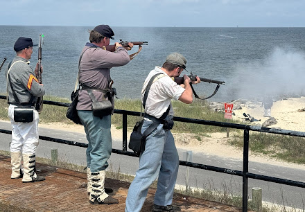
We attended an April battle reenactment at Fort Gaines (Picket photo)
“Denbigh was one of the last runners out of Mobile in 1864, and was destroyed as one of the last two runners trying to get into Galveston in May 1865. I was part of the project that excavated that ship in 1997-2004.”

After the fall of Fort Gaines, Yankee troops moved on Fort Morgan across the bay, forcing its surrender on Aug. 23, 1864. (The state park had a 160th anniversary living history on Saturday, Aug. 3.)

Mobile was heavily fortified and the Union command moved on after securing the bay. The city surrendered in April 1865, three days after Appomattox.

Ironclad braved minefield to protect wooden ship

In its rather brief life, the Tecumseh first experienced Confederate mines and obstructions during operations in the James River in Virginia. Thomas E. Nank, in two articles for the American Battlefield Trust, provides copious details on the “Forgotten Monitor.”

The Union Navy was intent on neutralizing CSS Tennessee, shown after the war. (U.S. Navy)
Before Mobile Bay, Farragut asked for more monitors to challenge the Tennessee and other Confederate warships. The Tecumseh was sent south, and it needed engine work twice on way, including in Pensacola, Fla.

Between 16 and 18 Federal ships, in two lines, would storm past Fort Morgan, trying to get under the guns, enter the bay and take the fight to opposing ships. Craven, who had expressed some doubts about the effectiveness of monitors but agreed to serve, was first in line on Aug. 5.

The commander, as he entered a mine field, decided to make a turn so he could take on the CSS Tennessee and protect USS Brooklyn, a wooden vessel that had faltered amid gunfire from Fort Morgan and the Confederate ships nearby.

Sign on Fort Morgan parapet describes battle, loss of Tecumseh; buoy is beyond (Susan C. Gast)
While Confederate mines were often faulty, at 7:40 a.m. a torpedo (or mine) detonated on the starboard side, according to Nank. The ironclad rolled over to port as water rushed in and panic ensued.

Gunners mate Samuel Shinn, one of about 20 survivors, wrote, “It seemed as if we were lifted right out of the water. At the same time, a blinding flash like lightning came through the porthole. A large hole was stove in the vessel's side, and the men below commenced to cry that the vessel was sinking.”

'After you, pilot.' Chivalry amid disaster

Almost all men below deck on Tecumseh were doomed, but Craven and a few others who were in the turret, pilot house or elsewhere topside had a chance.

Alfred R. Waud's account of Craven's heroics (Library of Congress)
Civil War historian and author Ronald S. Coddington wrote two articles about the USS Tecumseh in his Military Images magazine. He and Hall make special note of what its commander said as the vessel was in its death throes.

Craven and civilian harbor pilot John Collins, in the conning tower or pilot house, stepped toward a ladder that would take them to safety. “After you pilot,” said Craven, who never made it out an drowned in the maelstrom. His act of chivalry is venerated in the annals of naval tradition.

In the March 2020 issue of Military Images, Coddington laid out other versions of what Craven said. He included excerpts of a poem that detailed the officer’s chivalry and sacrifice. (At right, Tecumseh paymaster George Work / Library of Congress)

Collins, quoted in the 1888 “Battles and Leaders of the Civil War,” said after he spoken with the skipper, “When I reached the upmost round of the ladder, the vessel seemed to drop under me.”

In another telling of the story, Coddington wrote, Craven yelled to Collins, “You first, sir.” 

An 1879 account of the encounter offers another version of events. It appeared in “A Sketch of the Battle of Mobile Bay” by William F. Hutchinson, assistant surgeon of the sloop Lackawanna.

“Captain Craven was already partly out, when the pilot grasped him by the leg, and cried ‘Let me get out first, Captain for God’s sake; I have five little children!’ The Captain drew back, saying ‘Go on, sir,’ gave him his place, and went down with the ship while the pilot was saved.”

Farragut's sailors regrouped and won the day

After the Tecumseh sank, amid "immense bubbles of steam, as large as cauldrons," Farragut realized his mix of wooden and iron vessels, now in disorder, had to plow ahead.

William H. Overend's 1883 painting of the USS Hartford at Mobile Bay (Wikipedia)
“The vision of Farragut lashed with rope to the rigging of his flagship Hartford is indelibly etched into the American memory,” wrote Coddington. “His stirring words, paraphrased as ‘Damn the torpedoes, full speed ahead,’ are part of our national vocabulary.”

The Federal fleet went on to victory, capturing the Tennessee, while other Rebel ships slipped away, were captured or sank. Admiral Franklin Buchanan, commander of the Confederate fleet, was on the Tennessee and was gravely wounded and captured. (The conquest of Mobile Bay also gave a huge boost to President Abraham Lincoln's re-election bid.)

In a brief congratulatory order issued the next day, Farragut paid tribute to Craven, paymaster George Work and their crewmates, Military Images detailed in December 2014.

“It has never been his good fortune,” Farragut stated in the third person, “to see men do their duty with more courage and cheerfulness, for although they knew that the enemy was prepared with all devilish means for our destruction, and though they witnessed the almost instantaneous annihilation of our gallant companions in the Tecumseh by a torpedo, and the slaughter of their friends, messmates, and gunmates on our decks, still there were no evidences of hesitation in following their commander in chief through the line of torpedoes and obstructions.”

Gunner Charles Baker, serving on the USS Metacomet, helped save 10 Tecumseh crewmembers while under fire and later received the Medal of Honor (photo above, U.S. Navy)

Protection and dignity for a war grave

After the war, Tecumseh families railed against granted salvage rights, and the wreck was left undisturbed for a century. Heather Tassin, site manager at Fort Morgan, says the site is believed to be the largest maritime war grave in the continental United States.

A Smithsonian Institution expedition in the 1960s rediscovered the wreck, and surveys were later conducted, including one in 2018. There was talk of raising the Tecumseh, but it never happened. The Naval History and Heritage Command has about 65 artifacts from the wreck, according to an article. Items include ceramics, ship fittings and hull and deck plank samples.

The NHCC said a management plan continues protection and preservation of the site.

"It is a common misconception that anyone can dive on the Tecumseh," Tassin told the Picket in an email. "No one is permitted to dive on the Tecumseh. It is respected and protected as a war grave."
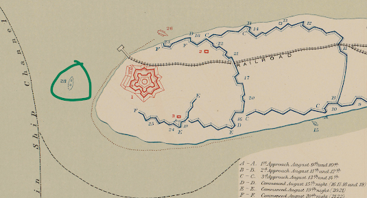
(Atlas of the Official Records, Plate LXIII, map 6)
A 1975 National Register of Historic Places form says most of the wreck (circled in green above) was covered in mud. "It was this coverage of silt which has given the ship and her contents protection against the ravages of underwater encrustation."

The federal government does periodic remote sensing to monitor the Tecumseh and ensure that it is still protected by anaerobic mud, said Tassin. Alabama officials monitor the work.

Any proposed research would require a permit from the Alabama Historical Commission and the Navy. “There would have to be a very compelling reason to conduct said research because of the Tecumseh’s status as a war grave and the fact that it has been investigated in an archaeological study in the past,” said Tassin.

In his Emerging Civil War article, Mackowski wrote about memorials to the USS Arizona (Hawaii), USS Indianapolis (Indiana) and USS Monitor (Virginia) – places where people can walk to, unlike the Tecumseh.

“But in those moments I stood at the mouth of Mobile Bay off the shore of Fort Morgan, I heard that lone buoy speak volumes. It reminded me of all the stories lost at sea, untold, unremembered. There are no monuments on the ocean.”