Showing posts with label trails. Show all posts

Monday, June 16, 2025

At Culpeper, a cadre of friends groups paved the way for a new Virginia state park that will tell the story of four battles. The idea: Preserve it and people will come

Cunningham Farm wall remnants (Chuck Laudner/ABT), Gens. John Buford and WHF "Rooney" Lee; 8th Illinois Cavalry attack along Beverly's Ford Road at Brandy Station (Keith Rocco/ABT)
A low stone wall that separated two 19
th-century farms in Brandy Station, Va., is remarkably intact today, despite being worn by time and a mammoth cavalry clash that signaled the beginning of the Gettysburg campaign.

It was here on June 9, 1863, where Union Brig. Gen. John Buford tried to turn the Confederate left flank. Brig. Gen. William Henry Fitzhugh "Rooney" Lee, son of Gen. Robert E. Lee, had no intention of allowing Buford's maneuver to succeed. Lee’s horsemen stubbornly fought off repeated assaults for five hours, stalling the Federal advance.

The site of their pitched fighting is on preserved ground that the American Battlefield Trust (ABT) will donate to the state for its burgeoning Culpeper Battlefields State Park, which will be made up of several parcels in Northern Virginia.

The trust, Friends of Culpeper Battlefields, the Brandy Station Foundation, Friends of Cedar Mountain Battlefield and other groups have worked for decades to save and interpret imperiled Civil War battlefields in Culpeper County. They are Brandy Station, Cedar Mountain, Kelly’s Ford, Rappahannock Station and Hansbrough's Ridge.

About 263 acres centered at the crest of Fleetwood Hill at Brandy Station were the first donated to the state.

While the state park opened a year ago, development is still in its embryonic stage. Staff is being hired to develop a master plan. Drew Gruber (left), former executive director of Civil War Trails, was recently hired as the park's first manager.

The ABT – which will be chief steward of the properties until 2027 -- plans to make several additional donations to the Commonwealth over the next couple years, said Jim Campi, chief policy and communications officer.

“I think it is one of our biggest accomplishments by far,” Campi said of the land preservation organization’s efforts in Culpeper County.

Ultimately, he said, visitors will be able to enjoy Brandy Station through a wide array of transportation – on foot, horseback, bicycle and canoe or kayak.

The ABT and the state hope the new park units and ensuing visitation will provide a boost to the local economy. Culpeper is nestled between Cedar Mountain and Brandy Station. “Downtown Culpeper is part of the Civil War story, anyway,” said Campi.

Click map to get a closer view of planned state park properties (American Battlefield Trust)
“Where else can you stand in the footsteps of soldiers, follow cavalry charges on horseback or paddle the battle?” Gruber said in a news release about his hiring. “This park already offers a unique set of experiences for visitors of all ages and interests, and I am excited to share these gifts with our guests.” 

43rd state park in Virginia a rare foray into history

Greg Mertz, vice president of the Brandy Station Foundation, said local groups are committed to supporting the state park in the long haul, whether through volunteering, fundraising or participating in special events.

That commitment was a big draw for Gov. Glenn Youngkin and the Virginia General Assembly when they first appropriated funds in 2022.

A pair of cannons at Cedar Mountain (Matthew Hartwig/American Battlefield Trust)
“We have been told that one of the reasons why the Culpeper Battlefields State Park has come into being before some other equally deserving new state park proposals is because of the number of friends groups and partners willing to both advocate for the park and help out with volunteers,” Mertz told the Picket in an email.

Campi said Virginia's park system "is mostly about managing natural parks and wildernesses,” so this Civil War site will indicate a new effort to convey the Commonwealth’s rich history. Culpeper will be the state's 43rd park and encompass about 2,200 acres.

While many portions of the Cedar Mountain and Brandy Station battlefields have been open to the public for years, including trails, the Fleetwood Hill unit of the Brandy Station battlefield is the only portion of the Culpeper Battlefields State Park that is currently open to the public, said Mertz.

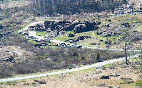
Interpretation at Brandy Station's Fleetwood Hill sector (American Battlefield Trust)

Public hearing will spotlight cool features

The ABT, working with the Brandy Station Foundation and other partners, is engaged in a yearlong cultural landscape study that will help inform the state’s master plan.

Campi said this study focused on a portion of the Brandy Station battlefield, including St. James Church and Elkwood. “We have identified some pretty interesting archaeological resources we are going to identify publicly,” he said.

Those features include an old road and cemeteries. The stone wall that separated the Cunningham and Green farms will be among discussion points at a June 24 evening program in Culpeper about the study.


An ABT marker about fighting at the Cunningham farm details the action. (Above, American Battlefield Trust map of Brandy Station. See top to see where Buford and Lee clashed)

Rooney Lee was a skilled fighter and used the terrain well. First, he blocked Buford's progress by the stone wall 500 yards in front of you.

“From his command post on the knoll behind you, Buford saw that a portion of Lee's dismounted regiments were placed between Ruffans Run and the Hazel River (to your left and right respectively). Two unlimbered cannon were located on the other side of the hill behind the stone wall. Since the disposition of the enemy and the channels of the two water courses left him no alternative, Buford launched several mounted and dismounted charges against the wall. Blistering fire from Lee's brigade held the Federals back for several hours.”

Rooney Lee’s cavaliers eventually left the field as an additional Federal cavalry force entered the fray. Casualties at and near the stone wall were significant.

U.S. cavalry earned their stripes at Brandy Station

The Friends of Culpeper Battlefields provides details on Brandy Station, Cedar Mountain, Rappahannock Station and Kelly’s Ford at this page. Cedar Mountain is famous for Confederate Maj. Gen. Thomas J. “Stonewall” Jackson’s August 1862 victory over Federal forces led by Maj. Gen. Nathaniel Banks. This battle shifted fighting in Virginia from the Peninsula to Northern Virginia, giving Lee the initiative, according to the National Park Service.

The NPS says this about Brandy Station:

“Enduring a narrow defeat and forced to withdraw, the Union force did not succeed in their mission to stop the Confederate advance. However, for the Union cavalry, the confidence and experience they gained at Brandy Station would prove invaluable four weeks later at a battlefield in southern Pennsylvania called Gettysburg.”

“It is just picturesque. It is beautiful,” Campi said of Brandy Station. Fleetwood Hill is just stunning.” He mentions the role of Beverly’s Ford Road, which is still unpaved in the battlefield. He also touts the important of archaeology work at Hansbrough’s Ridge.

Rappahannock Station witnessed fighting in 1862 and 1863. Some battleground has been lost to residential development.

These walls do talk. Will state take over Graffiti House?

Mertz, with the Brandy Station Foundation and a retired supervisory historian at the National Park Service, said besides owning parcels of land at Brandy Station and Kelly’s Ford, the nonprofit owns the Graffiti House (left), which is open Saturdays from 12 p.m.-4 p.m. from mid-March to early December.

“Walls in the 1858 building-- which is listed on the National Register of Historic Places -- contain Civil War graffiti,” he said. 

“The charcoal graffiti includes signatures, unit designations, dates, drawings and messages written by both Federal and Confederate soldiers.”

Mertz believes future master planning by the state could look at whether the house should be part of the park. “We envision that the options for ownership and operation of the Graffiti House vary from the BSF retaining both, the state taking over both, the state taking ownership but the BSF continues to run the operations.”

Hansbrough's Ridge -- scene of a small engagement during the battle of Brandy Station as well as a site from the Federal winter encampment of 1863-64 – will require extensive planning to provide visitor access and still preserve the resources on the site, Mertz added. 

View from Hansbrough's Ridge captures beauty, development (Peter Giraudeau/American Battlefield Trust)

Coming up with the right master plan is key

The ABT said it and other groups worked together to stave off much of the development that would take in battlefield land.

“At various times, pieces of land that we are now gifting to the Commonwealth of Virginia were slated to become housing tracts, industrial parks, water retention and management areas — even a Formula One racetrack,” it says. (Below, American Battlefield Trust map of parcels at Brandy station; click to enlarge)

State and private money are crucial to protecting more land as the development wave continues, said Campi, adding it’s important for the public to have access to history.

“We think this is going to add so much tourism potential,” said of the state moving in with a deeper budget and staffing than the advocacy groups. “We expect to see that explode in the next decade.”

Coming up with the master plan will take a few years as the state determines what it can open and what is vulnerable and needs extra protection.

In the meantime, visitors can walk on several trails and read ABT and Civil War Trails signs.

“We are always going to be involved,” said Campi. “The park is not done yet. There is more land to acquire.”

Thursday, July 20, 2023

Civil War Trails places marker at Gettysburg's Shriver house, scene of sharpshooters and chaos during battle

A Civil War Trails marker has been placed in front of the Shriver house in Gettysburg, detailing the family that fled during the July 1863 battle and the Confederate sharpshooters who fired from the attic.

“For many visitors the story of the battle is only focused on the soldiers, and not the women and children who endured the days before, during, and after,” said Civil War Trails executive director Drew Gruber in a press release. (He is at left with Nancie and Del Gudmestad, owners of the house)

“The Civil War Trails sign will help to encourage guests to take a tour of the Shriver House to understand the story of the Shriver family -- an ordinary family caught up in extraordinary circumstances.”

The Shriver House Museum at 309 Baltimore St. details the sharpshooters’ nest and provides a history of George and Hettie Shriver and their young daughters Sadie and Mollie. A 19th-century period garden welcomes visitors.

While George was serving with the Union cavalry, Hettie fled to her parents’ farm as Rebel forces moved in. Union forces said they killed at least two of the sharpshooters operating from the Shriver house. The Confederates fired upon Union troops on Cemetery Hill from two holes made in the brick.

Hettie, her girls and a neighbor returned home a few days after the battle.


“What she and the girls saw along the way would be etched in their minds forever. More than 7.000 soldiers and 5,000 horses and mules were killed during the battle,” the museum website says.

“They walked by, and stepped over, rifles, swords, canteens, belts, broken wagons, shattered caissons, ammunition, cartridge boxes, blankets, shoes and knapsacks. They saw buildings which were destroyed, bloody scraps of uniforms, and body parts as well.”

George, Hettie, Sadie and Mollie (Shriver House Museum
The house, which had also been used as a hospital, had been emptied of food and much of its contents.

Numerous artifacts, including medical supplies and bullets, were found during an extensive restoration of the abandoned home in 1996. A child's shoe is believed to have belonged to one of the Shriver girls.

Thursday, September 29, 2022

Breaking news: Devil's Den will reopen Friday after six-month rehabilitation project, Gettysburg park officials say

The landmark in 1909, at the advent of the car era (NPS photo)
Devil’s Den, scene of fierce fighting during the July 1863 battle, will reopen on Friday after a six-month project that tackled erosion and unauthorized trails that created safety hazards, Gettysburg National Military Park announced Thursday.

The project reestablished the features that make up this segment of the battlefield and will allow visitors to better immerse themselves into the historic landscape that is essential to understanding the three-day Battle of Gettysburg,” park said in a social media post.

The work tripled trail access to those with disabilities, increased overall greenspace by trimming some trail space and added features that will help with water runoff. Slip-resistant steps replaced uneven and worn stone steps, officials said.

“Although the area will reopen to visitors, one central area will remain fenced to allow more time for further vegetation growth. The fencing in this area will remain until native grasses have fully established. This process may take up to two growing seasons – up to 2024. In the interim, all non-native vegetation will continue to be treated within the entire project area.

View of Devil's Den from Little Round Top (Wikipedia, Wilson44691)
The reopening comes amid similar work on Little Round Top, which closed to visitors in July. “The rehabilitation of Little Round Top will address overwhelmed parking areas, poor accessibility and related safety hazards, significant erosion, and degraded vegetation,” the park said.

After the park earlier this year announced the Devil's Den closure in a Facebook post, critics and supporters weighed in. One said the need for work at both areas has been known for years and the public will be disappointed that two landmarks would be closed at the same time. Others said people should be grateful the work is happening to perpetuate the memory of those who fought there.

Park spokesman Jason Martz told the Picket in a March email that the timing of the projects was a coincidence, but they are both meant to address problem areas.

Devil’s Den was the scene of fierce fighting on July 2, 1863, during the decisive battle. The boulder-strewn hill was the object of forces under Confederate Lt. James Longstreet. Rebels took the position and engaged in fire with Union troops on Little Round Top.

Volunteers recently assisted the park with clearing vegetation overgrowth at Devil's Den as it neared reopening. Park officials then treated stumps to prevent sprouting.

View of Devil's Den after volunteers cleared vegetation (NPS)

Tuesday, July 26, 2022

Rocky Face Ridge Park: North Georgia community celebrates 20-year effort to open scenic site featuring Civil War earthworks and recreation trails

Bob Jenkins (left) with reproduction 3-inch ordnance rifle at park. (Picket photo)
High above Crow Valley, on a ridge near Dalton, Ga., men of the 64th and 125th Ohio endured withering Confederate fire that cut down officers and enlisted men alike.

It was May 7-8, 1864, at Rocky Face Ridge, during the first battle in what became known as the Atlanta Campaign. Gen. William T. Sherman sent troops from the Chattanooga area as a feint while Maj. Gen. James B. McPherson rushed to Snake Creek Gap in a bid to cut Rebel forces off from a vital railroad.

But the feint did not come without cost: About 1,400 men from both sides became casualties in the fighting over several days at Rocky Face Ridge in northwest Georgia.

One of them was remembered Monday afternoon as Whitfield County and a host of Civil War, conservation, recreation and other entities formally opened Rocky Face Ridge Park just north of Dalton.

Georgia Division reenactors take part in ribbon cutting Monday (Picket photo)
Scott McIlvain was among the 100 attendees gathered under a pavilion on a sweltering day. His ancestor, Col. Alexander McIlvain of the 64th Ohio, died from wounds he received atop the ridge, which offered its defenders commanding views and defenses.

Rocky Face Ridge Park was 20 years in the making, following purchases of 625 acres -- in the shape of a rectangle -- on top of the mountain, and then 301 grassy acres below, where the ceremony took place.

The county touts the venue as a wonderful history magnet -- with the remains of Federal and Confederate earthworks, trenches, a replica cannon and 12 interpretive signs spread out over a 3-mile trail below the ridge. The signs have QR codes that link to online stories about the battle.

The purchases were in 2002 and 2016 (Courtesy of Whitfield County)
Many visitors will likely come for the recreation offerings, including 10 miles of bicycle trails and an area used for cross country runs.

It’s a beautiful setting, topped by the spiny ridge that offers breathtaking views.

“There are mountains on which you can see the whole Atlanta Campaign, from Lookout Mountain to Kennesaw Mountain, on a good day,” Kathryn Sellers, chair of the Dalton Historic Preservation Commission, told the crowd.

Getting to the mountaintop is not easy. It’s accessible from a bike trail, but officials are hoping a better-marked, hiking-only trail will one day be constructed. Visitors are rewarded with a great view and stone breastworks built by Confederate defenders.

T-shirt worn by bicyclists group features Civil War cannon (Picket photo)
The effort to open the park got a push in 2016 when the Southern Off-Road Bicycle Association (SORBA) became involved.

The association donated money and helped design the trail system. The Northwest Georgia chapter helps maintain the trails.

SORBA was able to convince officials that the trails would not damage Civil War features.

Gaye Rice, president of the local chapter of SORBA, told the audience on Monday that bicyclists using the Buzzard’s Roost trail come from all over the Southeast to ride the ridge. Riders have been using the trails for about two years.

One of a dozen markers placed on 300-acre tract below ridge (Picket photo)
Rocky Face Ridge Park was the site of two Civil War clashes.

Federal Maj. Gen. George Thomas probed the Confederate defenses in February 1864, ahead of the grinding march on Atlanta. The park is near Dug Gap, Mill Creek Gap and Tunnel Hill, other Civil War sites of interest.

And in early May, Union troops advanced toward Dalton, which was held by forces under Confederate Gen. Joseph E. Johnston. The Yankees “were the tip of the spear” that launched the Atlanta Campaign, said Jim Ogden, chief historian at Chickamauga & Chattanooga National Military Park.

Items shown Monday include detailed aerial view of ridge's top (Picket photo)
Sherman knew it would be impossible to take the mountain head on, but he wanted to divert his foe as McPherson moved to the south.

“At places, the crest of the ridge was only four-persons wide, with sheer drop-offs on either side. Confederates stacked rocks to create breast works and, where the ground allowed, dug earthen works,” says Emerging Civil War. “The line runs for miles, from the northern tip of the ridge southward to Mill Creek Gap and Dug Gap.”

Union troops were able to take part of the northern tip of the ridge in May, but attacks on the division of Maj. Gen. Carter Stevenson failed to dislodge the Rebels.


The American Battlefield Trust, which is a major player in the acquisition of Civil War battleground, has YouTube videos and articles about the fighting at Rocky Face Ridge and Resaca. It is here where Sherman and Johnston began their famous flanking game that eventually pushed the Confederates back to Atlanta.

One of the trust’s articles is a letter that was published in Confederate Veteran magazine in 1918. The author was Lt. Col. David H. Moore of the 125th Ohio, writing to a former foe. He describes the fierce fighting on the crest of Rocky Face Ridge. He suffered a hip wound from a bullet that killed another soldier. About 55 men in the regiment were casualties.

To the Confederate veteran, Moore (right) wrote:

“That night, as I recollect, your men reconsidered your purpose to hold the ridge, only to fall back to another and stronger position, thus inaugurating that series of unparalleled struggles which has gone down in history as the ninety days' battle. Your division was almost constantly opposed to us during the Atlanta Campaign. So accustomed had we become to your style of fighting and to the vicious soprano of your Minie balls and to the indescribable fury of your battle-shouts and charging-yells that it was lonesome when by chance we struck a stranger foe.

Johnston, surprised by McPherson’s move and seeing that Sherman was moving south, evacuated troops off the ridge and rushed them to Resaca. The Federal strategy had failed, given McPherson moved back to Snake Creek Gap when he thought his army might be in a precarious position. Sherman was angry about McPherson’s failure to attack and perhaps cut Johnston off from the railroad. The Battle of Resaca ensued, with Johnston having consolidated his troops.

Monday’s ceremony included a tribute to Mike Babb, the former Whitfield County commission chairman who was the driving force behind the park.

Three of several mounds showing position of Mississippi battery (Picket photo)
According to the Chattanooga Times Free Press, the $4 million effort was funded with about $3.2 million in local, state, and federal government funds, plus about $800,000 in grants. Numerous organizations supported the project, including the Georgia Battlefields Association and the Georgia Piedmont Land Trust

“The amazing thing about this park is how many people got involved in it,” said Babb.

Chris Welton, a trustee with the American Battlefield Trust, said partnerships resulted in a park that is a "poster child for what we are about." He cited funding from the National Park Service's American Battlefield Protection Program as a seed for preservation projects.

Following the ceremony, I was able to see Confederate trenches (left) and the remains of Stanford’s Mississippi battery. The unit fought in several major battles during the war, including Shiloh, Chickamauga and the Atlanta battles.

I am grateful for Brian Chastain, the county’s recreation director, and another employee for taking me there via a rugged utility vehicle. It's always poignant to see physical reminders of what occurred as Americans fought each other.

The remains of the entrenchments offer proof for a statement from Bob Jenkins, head of Save the Dalton Battlefields:

Dalton, Georgia, and the county she resides in, Whitfield County, have more undisturbed Civil War earthworks than any other county in the nation.

If you go: Rocky Face Ridge Park is accessible from 2209 Crow Valley Road, Dalton, Ga.

 Jim Ogden of Chickamauga and Chattanooga was among speakers (Picket photos)

Friday, March 11, 2022

Devil's Den, a rocky focal point on the second day of Gettysburg, will close for 6 months as park addresses erosion and safety issues

Visitors to Devil's Den a few years after the battle (Library of Congress)
A second landmark at Gettysburg National Military Park will close for several months this year for major rehabilitation.

Park officials announced Thursday that work at Devil’s Den is expected to begin on March 21. The closure will last five to six months as crews address “significant erosion and safety issues in this highly visited area of the battlefield.”

Devil’s Den was the scene of fierce fighting on July 2, 1863, during the decisive battle. The boulder-strewn hill was the object of forces under Confederate Lt. James Longstreet. The Rebels took the position and engaged in fire with Union troops on Little Round Top.

The park said the work is needed because of the erosion along existing walkways and from unauthorized social trails that have created safety hazards.

“The scope of the project will reestablish, preserve, and protect the features that make up this segment of the battlefield landscape,” it said in a statement. “These improvements will allow visitors to better immerse themselves into the historic landscape that is essential to understanding the three-day Battle of Gettysburg.

Crawford Avenue, Sickles Avenue and the Devil’s Den parking area will remain open as much as possible for visitor use. Adjacent battlefield locations, such as the Slaughter Pen, Devil’s Kitchen, and the Triangular Field, will all remain open. The construction contractor will occasionally need to close all road access around the area, but notices will be posted ahead of time, the park said.

View of Devil's Den from Little Round Top (Wikipedia, Wilson44691)
The announcement came about a month after the National Park Service detailed a rehabilitation project on Little Round Top, where Union forces fought off a furious Confederate assault, also on July 2.

Park officials said they are addressing ongoing problems at the overcrowded site. They cited erosion, overwhelmed parking areas, poor accessibility and related safety hazards, and degraded vegetation.

“This project will also enhance the visitor experience with improved interpretive signage, new accessible trail alignments, and gathering areas. These improvements will allow visitors to better immerse themselves into the historic landscape that is essential to understanding the three-day Battle of Gettysburg,” a news release said. 

An update this week said tree cutting was completed last month and the overall project is out for bid, with two contracts: one for overall construction and the second for revegetation of Little Round Top.

The closure of Little Round Top is expected to begin sometime between March 20 and June 21. The project will take up to 18 months to complete, officials previously said.

After the park announced the Devil's Den closure in a Facebook post, critics and supporters weighed in. One said the need for work at both areas has been known for years and the public will be disappointed that two landmarks will be closed at the same time. Others said people should be grateful the work is happening to perpetuate the memory of those who fought there.

Park spokesman Jason Martz told the Picket in an email that the timing of the projects is coincidence, but they are both meant to address problem areas.

Thursday, October 9, 2014

Read up, then walk Civil War battlefields

There are more than 300 miles of trails to explore in the 24 national parks designated as significant battlegrounds of the Civil War, according to the National Park Service. “The war really did touch pretty much every corner of America,” said Mary Koik of the Civil War Trust, an organization that works to preserve the battlefields. “You have battles fought from Pennsylvania all the way out through New Mexico.” • Article

Read more here: http://www.miamiherald.com/living/travel/article2624889.html#storylink=cpy

Read more here: http://www.miamiherald.com/living/travel/article2624889.html#storylink=cpy

Thursday, June 9, 2011

Trail club repairs ground around famous Kennesaw Mountain monument

Illinois soldiers made a valiant effort to take Cheatham Hill during the June 27, 1864, battle at Kennesaw Mountain, Ga.

Led by brigade commander Gen. Dan McCook, Union units charged up the hill, literally yards away from Rebels who plugged away at them. Eventually, Confederates on top of the ridge withdrew.

Confederate and Union entrenchments thrown up before and during the furious assault remain at the killing ground dubbed the “Dead Angle.” A memorial to Illinois troops recalls the mortally wounded McCook and his compatriots, who suffered horrific casualties.

Since 1914, perhaps the park's most famous monument has stood on the knoll, facing the wheat field from which Illinois units charged. Surviving Illinois veterans purchased 60 acres for the monument.

Time and erosion have taken their toll on the ground around the white granite memorial.

The Kennesaw Mountain Trail Club has had three work sessions for its grading project, intended to repair erosion and control water flow at the 25-foot-tall Illinois Monument.

"Our goal is to re-grade the area into sustainable contours that will route rain water away from the monument and into the woods," it said in its most recent newsletter. "We are also repairing the damage done two years ago during the heavy rains that affected most of Cobb County with severe flooding and erosion."

Three trails converge there: the Unknown Soldier trail, the Illinois Monument trail and the Cease Fire trail.

To learn more about the monument, call 770-325-0444770-325-0444 and enter stop #103.

Project photos by Scott Mackay, Trails Supervisor, KMTC

More information on trail club
Picket's profile of the organization

Monday, January 17, 2011

Markers dedicated Wed. in Macon, Ga.

Four Georgia Civil War Heritage Trails interpretive markers will be dedicated Wednesday (Jan. 19) in Macon, Ga.

The program begins at 10:30 a.m. at the Woodruff House, 988 Bond Street. Known during the war as the Cowles-Bond House, it was Union Major Gen. James H. Wilson’s headquarters after his 10,000 cavalrymen captured this city on April 20, 1865.

Three other markers will be dedicated. One recalls Camp Oglethorpe, a Federal officer’s prisoner-of-war camp located in Macon. Fort Hawkins was the site of Confederate artillery battery that helped defend Macon during a July 30, 1864, attack. The Macon Defensive Fortifications lie in historic Riverside Cemetery, home to one of only three still surviving segments of Macon’s once imposing ring of Civil War fortifications.

Following the dedication program, trolleys will transport visitors from the Woodruff House (operated by Mercer University) to and from each of the other three locations. • Details

According to the New Georgia Encyclopedia, Camp Oglethorpe was wedged between railroad tracks and the Ocmulgee River, the site was enclosed by a rough stockade on 15 to 20 acres. It operated two times in the war. By the summer of 1864, more than 2,300 Union officers were housed there. Shelter was barely adequate, and rations consisted of beans, cornmeal, and rice in meager amounts. The lack of sanitation, coupled with a dwindling diet, led to the usual litany of such diseases as chronic dysentery and scurvy. An official death total for the prison is unknown.

Tuesday, November 23, 2010

Alabama promotes Civil War trail

The state tourism agency is launching a new push to promote Civil War attractions across Alabama, according to the Associated Press. A new brochure highlights 47 sites and attractions. It includes the dates of 14 war re-enactments that are held each year. Prominent sites include the Capitol and the First White House of the Confederacy in Montgomery, along with Fort Gaines and Fort Morgan at the entrance to Mobile Bay, the AP says.

Friday, April 2, 2010

Civil War trails on Google Earth

I'm looking for more communities to get on this bandwagon in the coming months. The Pennsylvania Tourism Office is showing off its Civil War trails with an online tool that blends Google Earth, interactive GigaPan high-definition panoramic images, and informational narratives in the form of “story stops” about 40 historic destinations. • Article