Showing posts with label land trust. Show all posts

Friday, November 3, 2023

New marker on Hilton Head Island pays tribute to Black regiment that helped build Fort Howell to protect freedmen

Marker is unveiled at Fort Howell entrance (town of Hilton Head Island)
A new marker on Hilton Head Island, SC., highlights the role of the 32nd U.S. Colored Infantry in the construction of Fort Howell, built to defend Mitchelville, a village populated by formerly enslaved people during the Civil War.

“This is a great day for Hilton Head Island because it shines a light on a piece of our past that needed to be explained more in depth and needed to be spotlighted properly,” Mayor Alan Perry said in prepared remarks for Wednesday’s ceremony at the well-preserved site. 

Much of coastal South Carolina fells into Union hands relatively early in the war and the Federal army needed to create camps for tens of thousands of newly freed families.

Mitchelville was the first such community in the area. (At left, a photo at Fort Howell of a metal figure depicting a 32nd USCT sergeant, courtesy of Hilton Head Island Land Trust)

While a previous sign at the well-preserved Fort Howell declared the earthen fortification's purpose and for whom it was named, the new marker lists the 32nd USCT and the 144th New York infantry as its builders in the latter half of 1864.

The army wanted to thwart any Confederate raids on Mitchelville. A large military encampment called Camp Baird was built near the fort.

The town worked with the Hilton Head Island Land Trust, which owns and maintains the site, and the South Carolina Department of Archives and History to create the new marker. 

George Banino, president of the land trust’s board, told the Picket the marker was changed in response to comments, especially the Gullah community, about telling the human story. 

“As the location of the U.S. headquarters for the Union's Department of the South from six months after the start of the war until a year after the end of the war, Hilton Head Island has an important history to tell,” Banino said.  

Bridge at entrance crosses remains of moat (Wikipedia photo)

Perry said the new marker "conveys a single cohesive narrative of our history."

The Picket also reached out to Historic Mitchelville Freedom Park for comment.

Historical records show 500 officers and men from the 32nd USCT worked a few months to create the 3-acre Fort Howell. It was designed to be manned by artillerymen and as many as 27 large weapons, according to a news release from the town.

New marker at left replaced one at right. (Town of Hilton Head and Mike Sroud, HMdb.org)
USCT members faced discrimination within the U.S. Army and were not recognized as soldiers by the Confederacy, which threatened to execute or return them to slavery.

More than 180,000 men served in the USCT, about 10% of all Federal soldiers. More than 40,000 died of combat, illness and disease.

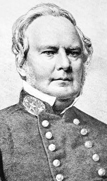
The post is named for Union Brig. Gen. Joshua B. Howell, who died in September 1864 after falling from his horse in Virginia.

Plan for the five-sided Fort Howell (National Archives)
Though Fort Howell never saw action, it is significant for its design and its structural integrity. It was listed in the National Register of Historic Places in 2011, according to the Historical Marker Database. 

“The fort, an essentially pentagonal enclosure constructed of built-up earth, is quite discernible despite natural erosion and the growth of trees and other vegetation,” says HMdb.org.

Fort Howell is the best-preserved earthen Civil War fort in South Carolina, although erosion has taken away some fine features, the trust says.

Rendering of what the fort, surroundings may have looked like
 (Mary Ann Browning Ford for Hilton Head Island Land Trust)
Over the past 10 years or so, the park has been transformed from a site containing some low earthen mounds covered by dense vegetation to a learning center for all visitors, Banino said. Improvements include extensive signage and walking paths.

“A large portion of the vegetation has been removed to enable visitors to view the structure of the fort, although enough vegetation has been retained to provide protection from continued erosion,” he said.

Exterior wall of fort across from moat (Hilton Head Island Land Trust)
Fort Howell, at 160 Beach City Road near the island’s airport, is open to the public with adjacent areas for parking. It has several interpretive signs and metal figures represent soldiers and others. It is open from dawn to dusk, according to the trust.

The town says Fort Howell is a key site on the National Park Service's Network to Freedom, which encompasses the Underground Railroad and the Civil War Discovery Trail.

Sunday, March 29, 2020

Pea Ridge National Military Park will expand with 140-acre historic farm that was site of troop movements, near field hospital

Williams Hollow Farm and bordering stream (Copyright The Conservation Fund)

A 140-acre parcel that was the scene of Confederate troop movements and a hospital during the March 1862 Battle of Pea Ridge in northwest Arkansas has been bought by a coalition of conservation and historical groups, with plans to donate it to the National Park Service.

The Williams Hollow Farm is surrounded on three sides by Pea Ridge National Military Park; the acquisition in effect fills in a missing puzzle piece.

The Conservation Fund and the Northwest Arkansas Land Trust earlier this month announced the purchase. Spokeswoman Ann Simonelli with The Conservation Fund told the Picket the seller is an extended family that has owned the property since the time of the battle.

Maj. Gen. Price
“There is nothing on the land at the moment. It is currently made up of forest and degraded field. The park service aims to eventually do restoration of the field to manage it as vegetation from the 1862 time period,” Simonelli said.

While the groups did not disclose the purchase amount, it is believed to be in the hundreds of thousands. The Pea Ridge National Military Park Foundation is helping with fund-raising to cover the purchase and eventual donation of the property to the federal government.

Among those efforts is NWA (Norwest Arkansas) Gives on April 2.

The March 6-9, 1862, Battle of Pea Ridge (Elkhorn Tavern) has been called by some historians “the Gettysburg of the West.” Forces under Union Maj. Gen. Samuel Curtis defeated the men of Confederate Maj. Gen. Earl Van Dorn, whose leadership has been faulted by historians. The Union won control of Missouri and weakened the Confederate hold in Arkansas.

“It is no exaggeration to say that the Pea Ridge campaign permanently altered the balance of power in the Trans-Mississippi. Few Civil War operations had such an impact on the course of events,” according to the National Park Service.

Kurz & Allison's fanciful depiction of battle (Library of Congress)
Jami Lockhart with the Arkansas Archeological Survey performed research on the Williams Hollow Farm and surrounding areas that played a part in the battle.

Confederate and Federal units clashed at Cross Timber Hollow and the Tanyard area north of Elkhorn Tavern. Rebel troops likely traversed the ground comprising the purchased property. Missouri State Guard troops under Maj. General Sterling Price emerged from Williams Hollow on March 7 as part of a drive on the Union right flank, according to histories.

The coalition cited other historical aspects of the area.

Lockhart wrote: “The historic Telegraph Road approaches to within 150 feet of the conservation property, and runs roughly parallel with the property along the entirety of its eastern boundary. Telegraph Road (also known as Old Wire Road) is integral to the history of the region. This road formed a portion of the route associated with the forced relocation of thousands of Native Americans, and is commonly known as the Trail of Tears. It was the route of the Butterfield Overland Mail and Stage line serving the area between St. Louis and San Francisco during the period 1858 to 1861. Telegraph Road was also the primary transportation artery in the area during the Civil War. Telegraph Road is especially well-known for its central role in the Battle of Pea Ridge.”

Sunset at Pea Ridge National Military Park (NPS)
During the night of March 7 into March 8, 1862, both armies concentrated forces on Telegraph Road. A powerful Union bombardment and assault on March 8 put Confederates into a retreat.

It’s not just the Civil War aspect of Williams Hollow Farm that is important, the groups said in their announcement.

“Once protected, the Williams Hollow Farm will secure the view shed of the Pea Ridge National Military Park and conserve mature forest habitat for migratory songbirds and rare bats, including the threatened northern long-eared bat. Keeping the property undeveloped will also help provide water quality protection of Sugar Creek within the Elk River watershed.”

Pea Ridge National Military Park Superintendent Kevin Eads told the Picket the acquisition would help protect and preserve cultural and natural resources. 

Jackie Crabtree, mayor of the town of Pea Ridge and head of the Pea Ridge National Military Park Foundation, said during the time of fundraising the Northwest Arkansas Land Trust will work with the park staff to keep the property maintained. The tract currently has a large open field surrounded by timber.

Rock formations at Williams Hollow Farm (Copyright The Conservation Fund)
Crabtree said the purchase was a rare opportunity to protect such property during a time of rapid growth in the region.

Needless to say, the Civil War is an important part of the town’s background and tourism.

“There are several families still in the area that were here during the battle,” Crabtree told the Picket. “The thing that makes Pea Ridge unique however is the naming of our streets. North/South streets are named for Union soldiers who fought in the battle. East/West streets are named for Confederate soldiers. This is set in city ordinance for developers.”