Helen Dortch Longstreet, Central of Georgia records (Atlanta History Center) and a Nancy Hanks ad (Wikipedia)
The archives
of Georgia’s first chartered railroad -- which during the Civil War moved troops and
supplies, lost locomotives, boxcars and miles of track to the enemy, even
suffering the indignity of its rails being fashioned into “Sherman’s neckties”
– have been moved from Savannah to Atlanta, where they eventually will be made more
accessible to researchers.
The Atlanta
History Center acquired the equivalent of three football fields of Central of
Georgia Railway records from the Savannah-based Georgia Historical Society,
which in turn received collections from the AHC. Among the latter are papers
relating to Helen Dortch Longstreet, stout defender of her husband, Confederate
Gen. James Longstreet.
The swap was
made possible through a $500,000 gift from Norfolk Southern. The idea is to
allow researchers to pore through consolidated collections in Atlanta or
Savannah – and not have to travel to both cities.
The collection includes records of affiliated and acquired rail lines (Atlanta History Center)
In 2021,
Norfolk Southern donated the Southern
Railway archives, dating to 1828, to the AHC.
“With the addition of the Central of Georgia Railway records, that
story is now more complete, offering a deeper look at how rail transformed the
Southeast,” Norfolk Southern said. Both railways were predecessors of Norfolk
Southern.
While researchers had been able to go
through some Central of Georgia records, many documents have never been
processed and were kept at a storage site in Savannah, officials said.
Jackson McQuigg, vice president of
properties for the AHC, told the Picket “the expectation is that processing and
indexing these records will make the materials of interest and available to
scholars and others beyond narrow niche groups.” In other words: a broader
audience.
Central of Georgia, founded in Savannah in 1833 as the Central Rail
Road and Canal Company, was a key transportation concern in the Southeast. It
merged with Southern Railway in 1963. Many Georgians remember the Nancy Hanks train that ran from Atlanta
to Savannah for decades.
Railroads were crucial to both sides during the Civil War. Several
companies operated in Georgia, and the Confederacy fashioned a network through
towns and larger cities where the lines connected.
Known as CentralRail Road
& Banking Co. of Georgia in the 1860s, the company was profitable for the
first few years of the war, according to a 1976 book by Richard E. Prince.
Its main line was from Savannah to Macon, with an extension
to Milledgeville – Georgia’s capital at the time – and Eatonton. It had
affiliates elsewhere.
It will take months to go through the trove of documents (Atlanta History Center)
The Coastal Plain region also produced valuable cotton for the Southern
war effort
In September 1863, the Central of Georgia and other companies
moved Longstreet’s corps from Orange Courthouse, Va., to North Georgia, where
they arrived in time to help deliver a blow against the Union army at
Chickamauga.
But the
relative good times for the resilient company came to an end in 1864 as Federal
troops descended on Atlanta and the heart of Georgia.
Locomotive 349 was built in 1891 and is on display in Chattanooga (Tennessee Valley Railroad Museum)
“Particularly for the first few months of the 1864 campaign,
both Sherman and Grant feared that the Confederates would send forces from
Virginia and the Atlantic Coast to Atlanta by rail, with the final link being
the Georgia Railroad,” said Charlie Crawford, president emeritus of the
Georgia Battlefields Association.
“All the rail
lines were important to supplying (Atlanta), though most of the foodstuffs and
animal feed came from the Macon & Western and the Atlanta & West Point,”
said Crawford.
While the
railway was still operational, trains were used to disperse the Confederate
wounded to hospitals east of Atlanta, including in Madison, Washington and
Augusta, he added.
Union Maj. Gen. George Stoneman’s botched cavalry July 1864
foray toward Macon dealt a punch to Central of Georgia, though it was able to
rebuild some infrastructure. More than 100 miles of track, along with station
houses, depots and other structures, were damaged or destroyed.
Sherman’s March to the Sea (illustration, Library of Congress, above) was even more crippling as the
wings of his army advancing on Savannah tore up track and burned locomotives,
bridges and boxcars.
Old articles in the Central of Georgia “The Right Way”
magazine detail some of the company’s losses. One calculated $1.6 million (in
1860s dollars) for reconstruction and losses, including $220,100 as the value
of enslaved people who got their freedom.
“These
figures do not include the value of 34 cars burned by Sherman’s troops, nor the
value of 95 cars lost on foreign roads, where some were sent to evade capture,
and some commandeered by the Confederate Government for its use. Neither do
they include the funds advanced to the Confederate Government, the depreciation
in Confederate currency held by the Railway, or the deferred repairs made to
engines, cars and roadway. In addition, many of the structures erected after
this raid and charged to cost of reconstruction of the road, were not as
substantial as the original ones, and were replaced by the Railway over a
period of many years.”
In 1862, the Central of Georgia had 58 locomotives and 729
cars. It maintained 49 locomotives and 537 cars in 1866, when service was
restored from Savannah to Macon. The Central of Georgia rebounded fairly
quickly after the war ended, providing passenger and freight service for
generations.
The Atlanta
History Center said by spring 2026 it will have completed the “discovery phase”
of what all is in the Central of Georgia papers, including records from the
Civil War era. (Replica of a Sherman Necktie at Fort McAllister, Ga., right)
McQuigg provided some context, starting with the 1833
formation of the Monroe Railroad and Banking Company, known later as the Macon
& Western.
“The Macon & Western was, of course, the third
railroad to reach Atlanta (after the Western & Atlantic Railroad and the
Georgia Railroad), in 1846. Although the Macon & Western was not acquired
by the Central of Georgia until after the Civil War, we’ve seen some
interesting Macon & Western materials in the collection, including maps
showing the railroad’s approach into Atlanta which identify the adjacent
property owners,” McQuigg said. “And we know that there are engineering
drawings of many of the Central of Georgia and Macon & Western’s pre-Civil
War structures, such as bridges. There is bound to be much more.”
Highlights from the collection include extensive
photographs of farms and communities along the routes of the Central of
Georgia. They were produced in the late 19th century, the AHC
said.
“Some of the railroad’s passenger and freight trains are
also depicted in the collection, including the well-known ’pocket streamliners,’
which ran passenger service on the railroad following World War II -- the
Atlanta-Columbus Man O’ War and the Atlanta-Savannah Nancy
Hanks -- as well as some of the through passenger trains operated by the
CofG,” said McQuigg.
In its early days, the Savannah-based railway printed its own currency
Allen Tuten, president of the Central of Georgia Railway Historical Society, said his organization has done substantial research in the
files when they were kept at the Georgia Historical Society.
“The society alsoinventoried/indexed all of the unprocessed files that had been instorage. We will be working with the AHC (as we
did with the GHS) toensure that all of
the files, documents and drawings are made availablefor researchers. The materials now at AHC comprise thelargest single collection of CofGa files,” Tuten
said.
For its part of the archives swap, the Georgia Historical
Society received several major manuscript and photographic
collections from the AHC that add to its existing collections.
“Many document pivotal moments in modern Georgia, including
portions of the Atlanta Committee for the Olympic Games photo archive and files
from the Georgia Film Commission,” an October news release said.
The GHS had two-thirds of the papers relating to Helen Dortch
Longstreet. The AHC had one-third, and sent them to Savannah. (At left, James and Helen in 1900, courtesy Dan Paterson)
Keith Strigaro, director of communications for the society,
said the Longstreet collectionconsists primarily of correspondence, with the majority
consisting of carbon copies of letters written by Helen Dortch Longstreet.
“The
correspondence covers her numerous interests, both personal and political.
Personal topics include family information, her health, her financial situation
and her passion to clear the name of her husband, General
James Longstreet. Contained in the political correspondence are letters to
many politicians covering topics such as elections, the New Deal, political
corruption in the Virgin Islands (also newspapers), and other political issues
she viewed as important.”
“A large portion of the collection describes her efforts to clear
General Longstreet's name. She attempted this through speeches,
publications, the Longstreet Memorial Association, and
the Longstreet Memorial Exhibit, both at the New York World's Fair of
1938 and the Golden Gate Exposition of 1940. There are also photographs of the
exhibit, the Longstreet Memorial and the 75th Gettysburg Reunion.”
Helen led a fascinating life and is remembered as a
progressive reformer, librarian, postmistress and riveter ata Georgia aircraft manufacturing plant during
World War II. Much of her time was advocating for James, who was villainized after the war by those who blamed him for the Confederate loss at Gettysburg and his postwar support of the Republican Party and Reconstruction.
She died in 1962, 58 years after her husband’s passing.
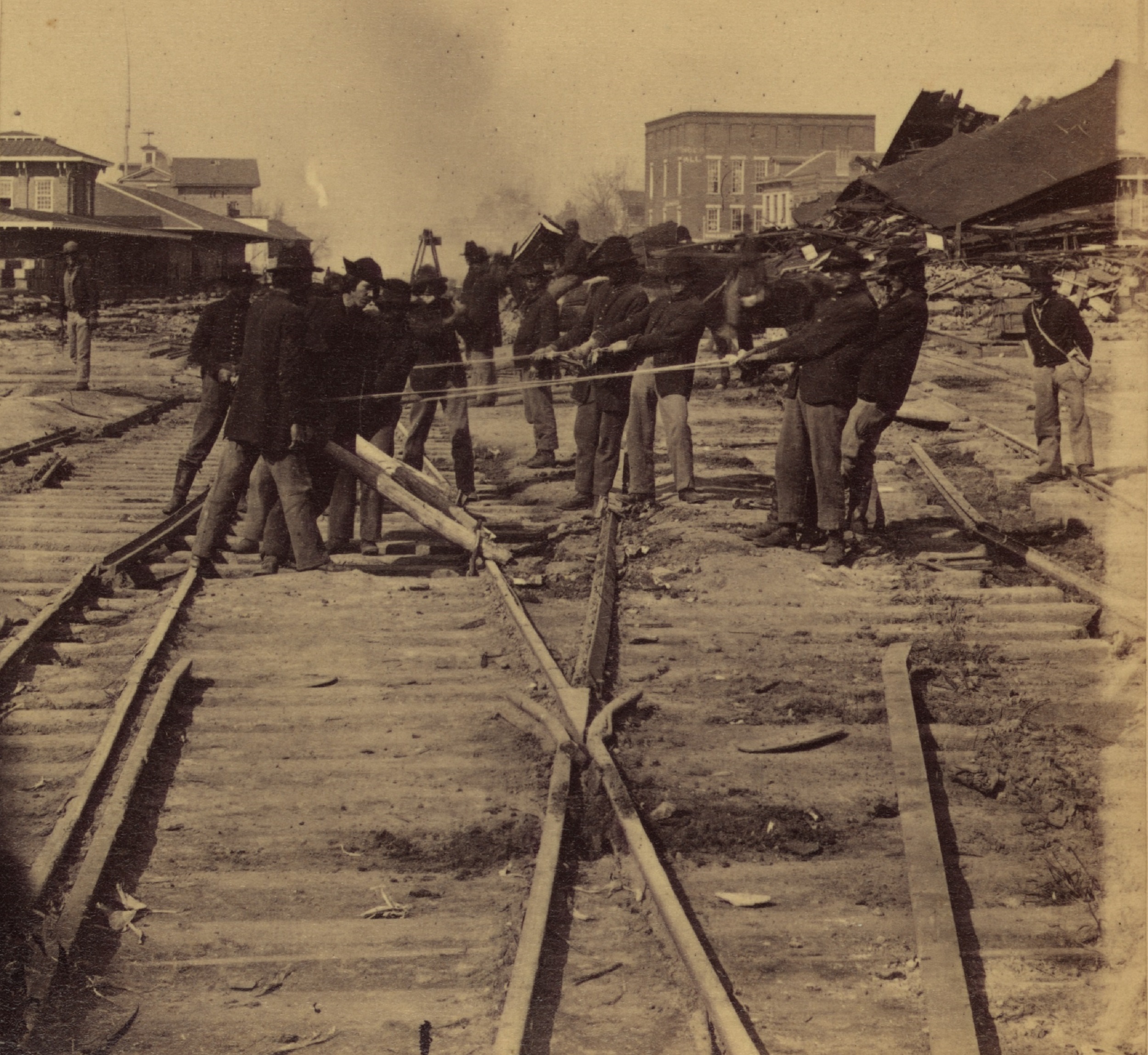
Barnard's fascinating photograph showing Union engineers (Library of Congress)
I’m a fan
of Garry Adelman’s Civil War Page on Facebook. The director
of history and education for the American Battlefield Trust regularly posts
photographs from the collection of the Library of Congress and other sources.
I
love his descriptions of Federal soldiers posing for the camera. Among them:
“Blue-eyed
dandy”
“Jaunty caps”
“Photobomber”
“A dude
checking his iPad”
You get the
idea. But an image he posted on January 4 of soldiers destroying Atlanta
railroad in November 1864 especially got my attention. George Barnard, a
contractor for the U.S. Army, took many photographs of the fallen city after he
arrived two months earlier, but I had never seen this one, for some reason. While
most of these fellas were just standing around, others were engaged in a flurry
of activity before the end of occupation and the commencement of the March to
the Sea.
Labeled “Gen.
Sherman’s men destroying the Railroad, before the evacuation of Atlanta, Ga.”,
the photograph was taken in downtown Atlanta not far from skyscrapers,
Underground Atlanta, Mercedes-Benz Stadium and the former CNN Center. (Detail from Georgia Battlefields Association walking tour map below)
It shows two
groups of men destroying railroad track and machinery, vital to Confederate
transportation in the Deep South. The larger contingent gazes at what appear
to be pipes or boilers. The freight depot for the Western & Atlantic
Railroad is in the background.
Barnard, a pioneer in the field, served as the official
photographer of the Military Division of the Mississippi, led by Maj. Gen.
William T. Sherman. He wasn’t primarily a photojournalist. A number
of his works were reproduced in the illustrated papers of the day, and some
stereographs were sold to a popular market.
On July 28, 1864, Capt. Orlando Poe, Sherman's talented chief
engineer, wired Barnard (right), who was in Tennessee: "Hold yourself in readiness
to take the field if telegraphed to that effect." A few days after Atlanta
fell, on September 4, Poe telegraphed Barnard to join him, shortly after Hood’s
Confederate troops, cut off from supplies, abandoned the city.
The Atlanta of the Civil War was a boom town, just beginning
to acquire the muscle and mettle that one day would make it the behemoth of the
South. In 1860, on the war’s eve, it had fewer than 10,000 residents, making it
the fourth-largest city in Georgia, behind Savannah, Augusta and Columbus.
With its nexus of four railroad lines, Atlanta quickly showed
its importance to the Confederacy and Federal forces who finally reached its
outer fortifications in July 1864. The city quickly descended into chaos as Rebel
troops were moved around and supply lines threatened.
Davis, author of several books on the Atlanta Campaign,
including “What the Yankees Did to Us: Sherman’s Bombardment and
Wrecking of Atlanta,” has written extensively about Barnard’s
documentation of the Union conquest of Atlanta, with scores of scenes showing
destruction, fortifications, a slave mart and Sherman himself.
In the volume “100 Significant Civil War Photographs: Atlanta Campaign,” Davis (left) said Sherman and Poe wanted their troops to destroy only
manufacturing and railroading capacity, which was concentrated in the downtown
business district. Federal soldiers, Davis wrote, started their own fires as
early as Nov. 11, 1864.
“We are fritened (sic) almost to death last night,” young Atlanta diarist Carrie Berry wrote. “Some mean soldiers set several houses on
fire in different parts of the town.”
Barnard ranks among the top echelon of Civil War photographers – Gardner, O’Sullivan, Cook, Rees, Reekie, Gibson and Brady.
The three photographs
I will be discussing here – showing destruction of the city’s railroad
infrastructure – were taken by Barnard in mid-November 1864. They likely were
taken within a short time of each other, and may include some of the same
troops.
What’s
going on in this picture?
It’s hard to
get a consensus because there were few detailed photo captions in those days and it’s
just plain difficult to know for sure, given several pieces of iron or steel
jammed together.
Poe, in his
set of images, wrote of this one: “View in Atlanta just before the ‘March
to the Sea’; showing manner of destroying Railroads and Machines.”
Jackson
McQuigg, vice president of properties for the Atlanta History Center, which
houses the giant Cyclorama painting and Civil War exhibits, said he thinks the largest
item in the foreground is a stationary steam engine (used for power
generation).
“The boiler is at right, while the stack is flopped over and laying on its side on top of
the engine itself,” he writes. “Even though the caption said that Sherman’s men
are destroying ‘the railroad’ I see rails at left … it sure looks like that’s
mostly pipe on the ground in the front. Maybe those were locomotive boiler
flues?”
Charlie
Crawford, president emeritus of the Georgia Battlefields Association, theorizes
the foreground may depict a boiler on the right and a detached exhaust chimney
(long tube) lying on a flat car.
“It could be
an exhaust chimney for any piece of machinery that creates heat by using
controlled flame,” he wrote. “The boiler is the item on the right of the flat
car. It still has an end cap, unlike the hollow tube. Could well be that
the exhaust chimney was paired with the boiler before the machinery was
disassembled.”
Commenters on
Adelman’s Facebook added these guesses:
The
‘toolbox’ looks to be a toolbox on top of a steam piston from a locomotive. A
boiler appears to be behind the smokestack and toolbox.....and there appears to
be steam pipe fittings on the platform as well.....possibly a disassembled
locomotive.
What
it is resting on to the right of the picture appears to be a steam engine
cylinder and valve box.
As for the
rest of the photo -- the men toward the back?
Michael Rose, curator of decorative arts and special
collections at the Atlanta History Center, said the smoke emanating from the
back half of the photo (above) are three fire pits built to heat the rails. The idea
was to warp and bend the rails and render them useless.
“I suspect the men are waiting for the
heat to do its job so they can do theirs before moving on to more,” Adelman wrote
in his Facebook post.
Later in this post, I examine two more destruction photos.
What exactly is that writing on the iron?
Zoom in on the flat car or platform and you will see a
horizontal piece of iron with writing. It’s tough to make out (and for me to brighten) but here are some posts from commenters on the Adelman Facebook post.
"Laimbeer
& Co. Atlantic Dock, Brooklyn, NY, 1855" which was one of the main
warehouse companies located at Atlantic Dock.
“ATLANTIC
DOCK BROOKLN NY 1855”
Rose said he can make out Brooklyn, N.Y.
“But not what
comes before it, undoubtedly the manufacturer’s name. It does look like it
includes “Atlantic” – but not in a way that look like Western & Atlantic
R.R.”
Who are these soldiers?
According to Steve Davis, Sherman initially assigned three
regiments of the provost guard to oversee the destruction: The 111th
Pennsylvania, 2nd Massachusetts and the 33rd
Massachusetts.
Their task to destroy track, the roundhouse, depots, the
railroad car shed and more, said Gordon Jones, senior military historian and curator at the Atlanta History Center.
The general changed his mind and brought in professionals --
Poe’s 1st Michigan Engineers and Mechanics and the 1st
Missouri Engineers – to carry out the work. The 58th Indiana also
pitched in, according to Crawford.
Poe (right), chief engineer of the Military Division of the
Mississippi, supervised demolition of the main passenger depot in downtown
Atlanta and many other buildings. He is remembered as a visionary engineer, for
both military and civilian service.
In his memoirs, Sherman wrote of “Poe’s special
task of destruction.”
Not only did Poe carry out the order to burn
Atlanta in 1864, he built the roads and bridges that made Sherman’s March to
the Sea possible, according to the National Park Service. “At the end of the
war, he was named brevet brigadier general. Since no system of medals existed
at the time, the brevet rank, meaningless in terms of real authority, served to
recognize gallant conduct or other meritorious service.”
Where
was the photograph taken?
Downtown
Atlanta was an extremely busy hub for railroads serving the city and much of
the South. The photograph was taken fairly close to the juncture of the Western &
Atlantic and Macon & Western railroads.
GBA map of downtown; W&A depot is shown at far left (Click to enlarge)
“In the background
is the W&A RR depot,” says Crawford. "Depot site would now be just west of
Ted Turner Drive and just northeast of “The Gulch.” Photo was taken from
WNW of the depot, about where CNN Center used to be.”
The W&A
roundhouse would be to the left, outside the image, said Rose.
The Barnard
photo below -- taken before its destruction by Yankee troops -- shows a different angle of the depot, this time with a large roundhouse in the background. The facility was used for servicing locomotives. (Photo: Library of Congress)
Barnard, of
course, wanted to make money from his work. Anthony & Co. published several of his photos. A December 2014
article in the newsletter for the Center for Civil War Photography featured
the photo of the machinery among others depicting destruction in the city.
“As Yankee
engineers proceed with their destructive work, smoke drifts past the ruins of a
destroyed building in this original Anthony stereo view. Indeed, there was
plenty to dread as night fell on Nov. 15, wrote John Kelley and Bob Zeller. “It
was, (Maj. Henry) Hitchcock wrote, “the grandest and most awful scene.”
When
was the photograph taken?
Regarding the
shot of the men standing around the metal pieces, Steve Davis believes it was taken
around Nov. 10-11, days before much of the city was torched.
Keith Davis (left),
a leading expert on Barnard, told the Picket the photos of soldiers
destroying railroad were likely taken on both Nov. 14 and 15. Sherman’s troops
began leaving the city before noon on the 15th to begin the march to
Savannah, Ga.
“On the following morning, the general staff, Barnard, and the remainder of the Union
forces marched out of the shattered city,” Davis wrote in a book about Barnard.
“So, I have to think that Barnard was extremely active
on Nov. 15; thus, making
it correct to date these as Nov. 14-15,
rather than strictly the 14th,” he told the Picket.
Crawford doesn’t
believe the photographs could have been taken Nov. 15.
“We can date these photos because they depict activity,
and we know the car shed and rail lines were destroyed on 14November. Since the armies left town
on 15 November,
the photos must have been taken on the 14th. Barnard may have
taken images as the armies were leaving, but the destruction was completed on
the 14th."
The one major
gap in Barnard’s Atlanta photography is that no images exist showing the vast
panorama of destruction after the fires of Nov. 15 and 16, according Kelley and
Zeller in the “Battlefield Photography” newsletter.
What about the two other soldier photos?
Union engineers destroying track; Western & Atlantic depot behind (Barnard, Library of Congress)
You probably are familiar with two more photographs
showing groups of men heating and damaging rail so that the South cannot
quickly get the trains running again after the Federal army ends its two-month
occupation of Atlanta.
The first photograph described here was taken very
close to the main image we have been discussing. Barnard must have moved his
camera forward. If you look closely, you can see the men working amid iron
rail, wooden ties and other infrastructure.
The photograph with all the machinery shows a
particularly tall soldier. I am trying to place him in this photo, and I
wonder if he is the man wearing a hat with a round crown, his face not visible to
the camera. But the hats don’t exactly match. I welcome guesses from anyone
reading this. These men are believed to be from the 1st Michigan and
1st Missouri engineers.
The second photograph, a vintage original stereo view, depicts men heating
track near the destroyed car shed, about 700 yards east-southeast from the
machinery shot.
Sherman's men do their work; behind right are remnants of car shed (Barnard, Library of Congress)
Union troops used large iron bolts and others items to knock down the arch supports before setting fire to the remains. This was a
devastating loss for Atlanta. The car shed was a cooperative venture of the
four railroads that served the Georgia city and the Confederacy. The
station had been a fixture for about 10 years.
This scene is mostly covered today by the Central Avenue overpass downtown. Smoke from burning
railroad ties rises in the background, according to Kelley and Zeller, who date
the photograph to Nov. 15. The view is to the west, said Crawford. (Below is a photo of the car shed before its destruction)
“This has
been a dreadful day,” Carrie Berry wrote on Nov. 15. “Things have been burning all
around us. We dread to night because we do not know what moment that they will
burn the last house before they stop.” (Her journal is at the Atlanta History Center)
Modern view (below) is above where car shed was built (Library of Congress and Georgia Battlefields Association)
Those who
visit downtown, especially around Underground Atlanta, will notice many street
levels have changed in the past century.
“Present day photos are difficult because construction of
the viaduct system in the 1920s put the roads 20 to 30 feet higher than the
terrain shown in the 1864 photos,” said Crawford. “You can still look down from
a few vantage points onto the existing freight line and the two MARTA tracks
that occupy some of the space that the multiple rail lines once traversed.”
You can get an idea of the modern landscape from the photo (above) of Lot R parking area that is above where the car shed was formerly.
Sharing blame for all that destruction
Let’s briefly step back for a little background on what’s been termed in folklore as the Burning of Atlanta. About 40 percent of the city was in ruins when Sherman began his March to the Sea. But don’t lay all the blame solely at his feet.
“It started when Confederate military planners stripped and leveled buildings and homes on the city’s outskirts to build the extensive fortifications that Sherman found impenetrable,” reads an online presentation, “War in Our Backyards,” produced by The Atlanta Journal-Constitution and the Atlanta History Center for the 2014 Civil War Atlanta centennial.
Hood's troops blew up ammunition train before leaving (Barnard, Fleischer's Auctions)
“During the summer siege, Union artillery fire hit many of the city’s major structures, setting many afire. Miles of trenches dug by both sides scarred fields and roads. When the Confederates made their retreat, they blew up their ammunition train, damaging scores of homes, and burned the massive Atlanta Machine Works factory,” the AJC said.
Looters, arsonists and the need for material for Union forts took their toll until November 1864, when Sherman “ordered the destruction and burning of all facilities with potential military value, including ripping up rail lines and destroying Atlanta’s transportation infrastructure.” He ordered out the remaining civil population, who were offered a one-way train ride either north or south.
Steve Davis has written about how the fires spread to residences, and some Union soldiers decided to start some residential blazes of their own.
You can see sites in March walking tours
Sadly, virtually nothing from wartime downtown Atlanta
remains today and only a guided tour and some imagination can provide an
adequate picture.
Crawford
has led the GBA walking tour for 18 years. I went on a version in 2014 with
former The Atlanta Journal-Constitution editor Scott Peacocke in July 2014. I
enjoyed it and wrote about the experience here. “It rained buckets,” Crawford reminded me.
Scott Peacocke, Charlie Crawford and Mary-Elizabeth Ellard in 2014 (Picket photo)
Crawford
works from a downtown then-and-now map and a PowerPoint presentation with
Barnard photos. The slides include pointers and basic information. He then
takes participants around the area to see the “now” view to correspond to the
old images.
“It’s always
fun to hear people say that they had seen some of Barnard’s photos and
always wondered where they were taken,” he said.
Particularly
popular are references to the book and movie “Gone With the Wind", including a
scene in which Scarlett O’Hara approaches the car shed, which
had been turned into a receiving hospital under care of Dr. Meade.
She walks
through the expanse created by multiple rail lines, and hundreds of injured Confederate soldiers,
some on stretchers, some on the red soil or tracks, writhe in agony or lie
motionless. It is a powerful scene, punctuated by a tattered Rebel battle flag.
Crawford said
he gets a variety of reactions and questions during his tours.
“Discovering
that not all of Atlanta was destroyed is difficult for some to accept. Seeing
that the state Capitol is now on the former City Hall site seems to give most
people something they can surprise their family with.”
----
Georgia
Battlefields Association will again lead free Phoenix Flies tours GBA of Civil
War downtown Atlanta. Participants must preregister for the March 8 and 22
walks, which take about 2 hours and 45 minutes. The tours are limited to 25
people. Click here for more information. Registration for Phoenix Flies begins
Feb. 21.
A stretch of potholes, a view of Decatur Road in Cyclorama (Picket, AHC photos)
For many in the
Atlanta area, the only thing as exciting as the first-place Braves ballclub is
the current resurfacing of a vital road connecting the city and nearby Decatur,
Ga.
Commuters and
residents in the Inman Park and Candler Park and other neighborhoods have long
bemoaned the potholes, reversible lanes and too-scary-for-bicyclists
conditions. Maintenance was never a word associated with DeKalb
Avenue.
“A drag strip in a warzone,” the website Urbanize Atlanta observed, perhaps ironically, in a reference to car crashes and mishaps.
War zone indeed. Motorists who zip along the road might
notice a half dozen or more historic markers describing what happened during
the Battle of Atlanta in 1864.
Project overlaid on 1964 DOT map showing Battle of Atlanta (rendering W.D. Gast)
The avenue
back then was called Decatur Road, and it’s depicted in the Atlanta Cyclorama
painting and has a reference in “Gone with the Wind.”
The Atlanta
project -- which includes bike and turn lanes and intersection improvements --
stretches from Jackson Street near downtown Atlanta to Ridgecrest Road, several
miles to the east. The road was in the thick of things before, during and after the battle.
The avenue is bordered by the CSX (formerly Georgia Railroad)
and MARTA lines on one side, and residential neighborhoods and scattered
businesses on the other.
Site of artist tower at left looking at center of paintingk Atlanta skyline behind (Courtesy AHC)
(Full disclosure: I have traveled DeKalb
Avenue for years to work in downtown Atlanta and am very aware of the
potholes).
Decatur Road
featured prominently in the July 22, 1864, battle, says Charlie Crawford, president
emeritus of the Georgia Battlefields Association. Of course, it was a dirt road during the Civil War, and had it owns share of potholes and ruts. Commanders used the road to carry men, materiel and artillery.
The view toward Stone Mountain in Cyclorama; Decatur Road to right (Courtesy AHC)
The circular Cyclorama shows the road stretching to Atlanta and Decatur. It was a mere block from the Troup Hurt
House, the focal point of the painting depicting a brief Confederate
breakthrough.
“It was also
a main approach route for the Army of the Tennessee prior to the battle,” says Crawford,
referring to a large Federal unit under the command of Maj. Gen. James B.
McPherson, who moved his troops from Decatur toward advancing Confederates.
Charlie Crawford drew red lines showing road in Cyclorama
“As the Cyclorama illustrates, it wasn’t nearly as straight as it is now, curving to the south of the railroad and then curving back north at certain spots, including just east of the Confederate breakthrough,” he says.
Mary-Elizabeth
Ellard, GBA secretary and trustee, operates a veterinary practice along DeKalb
Avenue. “Many people forget that they live/work/play on
a battlefield,” she says.
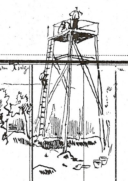
German
artists who created the Cyclorama in 1886 erected a tower on DeKalb Avenue near
the current Inman Park MARTA station.
To obtain perspective, they were able to see the road, the railroad and the site of a former Confederate iron rolling mill.
The Troup Hurt House was burned a day or two after the battle and the artists did not know its precise location 22 years later, said Gordon Jones, senior military
historian and curator for the Atlanta History Center, which houses the giant painting. The home was located on what is now Degress Avenue.
(The sketch at left, courtesy of the AHC, shows a similar tower in Chattanooga, Tenn.)
Admin Brad Butkovich mentioned fighting in
what is now called the nearby Little Five Points neighborhood and the various
markers that indicated troop positions and action.
“Many markers have been moved as roads and intersections have expanded and changed over the years,” one Facebook reader says.
Much of the
Battle of Atlanta occurred along and near the north-south Moreland Avenue,
which cuts under DeKalb Avenue and through Little Five Points. (Moreland Avenue is depicted
in a 1964 map above that has an overlay of the repaving project.)
MARTA rail line (left) along DeKalb Avenue (Picket photo)
Georgia State University details the histories
of streets during the Battle of Atlanta. Of Moreland Avenue, its website says:
“While this route may be a high-traffic residential road today, in
1864 it was little more than undeveloped farmland -- unremarkable in every way
except its role as the dividing line between Fulton and DeKalb counties.
However, as Sherman’s Federal armies made their way towards Atlanta, this
undistinguished strip of land would become the site of some of the fiercest
fighting experienced by participants of the Atlanta Campaign in the American
Civil War.”
A military map in the Library of Congress
collection (above, click to enlarge) clearly shows Decatur Road and the Georgia Railroad, troop positions
and a spot labeled “Rebel Barracks.”
The road was
mentioned during the 1939 film “Gone with the Wind.” The fictional Frank
Kennedy, a business owner and Klansman, took part in a raid on a shantytown,
ostensibly as revenge for an attack on Scarlett O’Hara.
O’Hara asks
Rhett Butler about the whereabouts of her second husband.
“He’s lying
out on the Decatur Road,” Butler replies. “Shot through the head. He’s dead.”
The $5.4 million project aims to make everyone safer, especially with the formal end of
reversible lanes. I drove the stretch this week and was heartened to see much
of it already paved. Work is expected to be completed in August.
Road work near old textile mill in Cabbagetown area (Picket photo)
Troup Hurt House is focal point of the Cyclorama (Picket photo)

.jpg)

.jpg)