Showing posts with label lanes. Show all posts

Wednesday, January 7, 2026

You can't drive to the top of Kennesaw Mountain anymore. But hard campaigners can still walk or bike up; weekend shuttle will go to daily in a couple months

Restriping and other work was scheduled to begin this week at the park outside Atlanta (NPS photo)
I drove Saturday morning (Jan. 3) across town to Kennesaw Mountain National Battlefield Park, hoping to drive to the top of the Georgia peak a couple days ahead of the formal closure of the road to private vehicles.

Oops.

The walk to the summit provides some pretty cool views (Picket photos)
I had forgotten Mountain Road wasn’t open to cars on weekends. OK, how about the shuttle bus operating next to the visitor center? Well, it wasn’t operating because of rainy conditions. So, I did what hundreds of people do every day: Walk the 1.6 mile paved surface to the summit.

I greeted fellow walkers and took in a few signs indicating Confederate cannon and defensive positions from June 1864.

There’s a few for Maj. Gen. Edward Walthall’s division, namely  Quarles and Reynolds brigades. At the top, I used a marker to match views of Marietta and Atlanta and saw one listing 14 Georgia generals who fought for the Rebel army at Kennesaw Mountain. And above that is a cool stretch of emplaced cannons mimicking the Confederate positions.

Beyond the history, you get great views of the skyline and buildings below as you walk the winding road. I returned via the same route because the popular walkup trail was a bit wet and I didn’t trust my knees and bum ankle. (For the curious, the summit is 1,808 feet above sea level.)

I imagine my experience of seeing the road entrance blocked will be a surprise to many visitors this week as the news spread that the park Monday closed the road to private vehicles seven days a week as part of a safety improvement project.

The aim is to reduce congestion, ensure safety and protect resources.

"This change in use addresses growing safety concerns on a narrow, heavily used road," said Acting Superintendent Beth Wheeler in a news release. "We understand this change may impact how some visitors experience the park, and we are committed to prioritizing a safe and accessible experience for all visitors while also preserving the natural and historical integrity of the park."

A marker provides details on what can be scene from near the summit (Picket photos)
The road to the summit will eventually be accessible daily by shuttle, foot and bicycles, the latter of which must follow a specific schedule. The unpaved walkup trail will not be affected by the project.

"Once construction is complete, the park will expand its existing weekend/holiday shuttle service to seven days a week." said Wheeler in an email to the Picket. She said the park has seen increased visitation and held a public comment period in summer 2024.

The bottom line for the next couple months: Visitors can walk up the mountain on the road or the trail, bicyclists can come each day and the shuttle still operates on the weekend.

Work includes restriping the road and improvements to the summit and shuttle plaza near the visitor center. 

Wheeler says there will be a pedestrian lane on the outside edge of the road. The pedestrian lane will be wide enough for both ascending and descending walkers. 

A wider lane will be available for the shuttle and bicycles. It will be separated from pedestrians by new striping.

I noticed Saturday, ahead of the closure, that walkers were spread out over much of the road, so it will be interesting to see whether rangers will be able to keep them to the designated lane. Perhaps there will be sticks or something similar to separate the two lanes. (At right, a walker carried this replica canteen up the road)

Cyclist access will be permitted daily from 7:30 a.m.-10 a.m. and 4:30 p.m.-8:30 p.m. (or 6 p.m. during winter hours) outside of shuttle operating times.

The road has a pretty good elevation grade increase in places and has a couple blind spots. And there's no shoulder lane. In other words, it has looked like any other old road -- with no marked spots for pedestrians.

Park officials say it has seen increased traffic incidents and medical emergencies.

While cars, when not attended to properly, are the most inherently dangerous of the three modes of transportation, pedestrians and bicyclists often have close calls and incidents.


Intermittent road closures to all forms of transportation will occur through late March, perhaps longer, the park said.

Visitor Ann Wright told the Atlanta CBS News affiliate that motorists sometimes sped up not matter how many strollers or bikes were on the road.

Some have questioned whether fewer people will make the trek to the top if they can't drive themselves.

A trail leads from Mountain Road to Little Kennesaw Mountain (Picket photo)
"I think it kind of shuts off a lot of availability for people who aren't physically able to get up there because I know it is kind of more of a strenuous hike, but I think it would be better for the park and for the conservation of the nature for sure," hiker Jenna Nation told the station.

Wheeler said the new shuttle schedule has not yet been set. The park will share information in the spring when the construction project is complete and the new uses and times for Mountain Road begin, she said.

The wartime version of the road going to the mountain top allowed Southern troops to haul cannon to the commanding heights.


Union forces on June 27, 1864, made demonstrations in the area (above), but the real attack occurred farther to the south. The assault was a costly – but temporary --failure as the army neared Atlanta.

There was no fighting at the summit during the Battle of Kennesaw Mountain.

Friday, June 16, 2023

Huzzah! A busy and scary Atlanta road is finally being repaved. It played a prominent part in 1864 Battle of Atlanta, is depicted in Cyclorama

A stretch of potholes, a view of Decatur Road in Cyclorama (Picket, AHC photos)
For many in the Atlanta area, the only thing as exciting as the first-place Braves ballclub is the current resurfacing of a vital road connecting the city and nearby Decatur, Ga.

Commuters and residents in the Inman Park and Candler Park and other neighborhoods have long bemoaned the potholes, reversible lanes and too-scary-for-bicyclists conditions. Maintenance was never a word associated with DeKalb Avenue.

“A drag strip in a warzone,” the website Urbanize Atlanta observed, perhaps ironically, in a reference to car crashes and mishaps.

War zone indeed. Motorists who zip along the road might notice a half dozen or more historic markers describing what happened during the Battle of Atlanta in 1864.

Project overlaid on 1964 DOT map showing Battle of Atlanta (rendering W.D. Gast)
The avenue back then was called Decatur Road, and it’s depicted in the Atlanta Cyclorama painting and has a reference in “Gone with the Wind.”

The Atlanta project -- which includes bike and turn lanes and intersection improvements -- stretches from Jackson Street near downtown Atlanta to Ridgecrest Road, several miles to the east. The road was in the thick of things before, during and after the battle.

The avenue is bordered by the CSX (formerly Georgia Railroad) and MARTA lines on one side, and residential neighborhoods and scattered businesses on the other.

Site of artist tower at left looking at center of paintingk Atlanta skyline behind (Courtesy AHC)
(Full disclosure: I have traveled DeKalb Avenue for years to work in downtown Atlanta and am very aware of the potholes).

Decatur Road featured prominently in the July 22, 1864, battle, says Charlie Crawford, president emeritus of the Georgia Battlefields Association. Of course, it was a dirt road during the Civil War, and had it owns share of potholes and ruts. Commanders used the road to carry men, materiel and artillery.

The view toward Stone Mountain in Cyclorama; Decatur Road to right (Courtesy AHC)
The circular Cyclorama shows the road stretching to Atlanta and Decatur. It was a mere block from the Troup Hurt House, the focal point of the painting depicting a brief Confederate breakthrough.

“It was also a main approach route for the Army of the Tennessee prior to the battle,” says Crawford, referring to a large Federal unit under the command of Maj. Gen. James B. McPherson, who moved his troops from Decatur toward advancing Confederates.

Charlie Crawford drew red lines showing road in Cyclorama
“As the Cyclorama illustrates, it wasn’t nearly as straight as it is now, curving to the south of the railroad and then curving back north at certain spots, including just east of the Confederate breakthrough,” he says.

Mary-Elizabeth Ellard, GBA secretary and trustee, operates a veterinary practice along DeKalb Avenue. “Many people forget that they live/work/play on a battlefield,” she says.

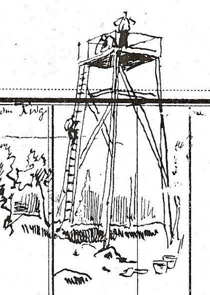
German artists who created the Cyclorama in 1886 erected a tower on DeKalb Avenue near the current Inman Park MARTA station.

To obtain perspective, they were able to see the road, the railroad and the site of a former Confederate iron rolling mill.

The Troup Hurt House was burned a day or two after the battle and the artists did not know its precise location 22 years later, said Gordon Jones, senior military historian and curator for the Atlanta History Center, which houses the giant painting. The home was located on what is now Degress Avenue.

(The sketch at left, courtesy of the AHC, shows a similar tower in Chattanooga, Tenn.)

I turned this week to the Atlanta Campaign History and Discussion Group Facebook page for feedback on the road’s Civil War history.

Admin Brad Butkovich mentioned fighting in what is now called the nearby Little Five Points neighborhood and the various markers that indicated troop positions and action.

“Many markers have been moved as roads and intersections have expanded and changed over the years,” one Facebook reader says.

Much of the Battle of Atlanta occurred along and near the north-south Moreland Avenue, which cuts under DeKalb Avenue and through Little Five Points. (Moreland Avenue is depicted in a 1964 map above that has an overlay of the repaving project.)

MARTA rail line (left) along DeKalb Avenue (Picket photo)
Georgia State University details the histories of streets during the Battle of Atlanta. Of Moreland Avenue, its website says:

“While this route may be a high-traffic residential road today, in 1864 it was little more than undeveloped farmland -- unremarkable in every way except its role as the dividing line between Fulton and DeKalb counties. However, as Sherman’s Federal armies made their way towards Atlanta, this undistinguished strip of land would become the site of some of the fiercest fighting experienced by participants of the Atlanta Campaign in the American Civil War.” 


A military map in
the Library of Congress collection (above, click to enlarge) clearly shows Decatur Road and the Georgia Railroad, troop positions and a spot labeled “Rebel Barracks.”

The road was mentioned during the 1939 film “Gone with the Wind.” The fictional Frank Kennedy, a business owner and Klansman, took part in a raid on a shantytown, ostensibly as revenge for an attack on Scarlett O’Hara.

O’Hara asks Rhett Butler about the whereabouts of her second husband.

“He’s lying out on the Decatur Road,” Butler replies. “Shot through the head. He’s dead.” 

The $5.4 million project aims to make everyone safer, especially with the formal end of reversible lanes. I drove the stretch this week and was heartened to see much of it already paved. Work is expected to be completed in August.

Road work near old textile mill in Cabbagetown area (Picket photo)
Troup Hurt House is focal point of the Cyclorama (Picket photo)