Larry Terrell
Crudup can trace his ancestors back to slaves working on a plantation in North
Carolina. But the Round Rock, Texas, resident doesn’t know what
happened to those slaves when they were freed after the Civil War, or whether
he’s related to any of the Crudups living on the East Coast. That’s why Crudup
is participating Sunday in a national project to put the records of freed
slaves into a free, searchable online database. The project uses records
gathered by the federal government when it started the Freedmen’s Bureau in
1865. • Article
Saturday, February 27, 2016


Wednesday, February 24, 2016
Kennesaw battlefield a step closer to expanding, adding historic Wallis House
 |
| The Wallis House about 10 years ago (Georgia Battlefields Association) |
A dilapidated
1853 farmhouse that at one point was in imminent danger of being demolished may
soon became part of Kennesaw Mountain National Battlefield Park, which could
use it to more fully tell the story of Union strategy in the battle and the
role of African-Americans in the Civil War.
Efforts to
have eight acres containing the Wallis House and Harriston Hill added to the park
in north Georgia have been more than a decade in the making. The U.S. House of Representatives on Feb. 24 voted in favor, with a similar bill to
be considered next by the Senate.
“It is very exciting
for us. We know that once this happens this is just a first step,” said park
Superintendent Nancy Walther. “We are really thrilled about the opportunity and
it is nice to ride the surf in.”
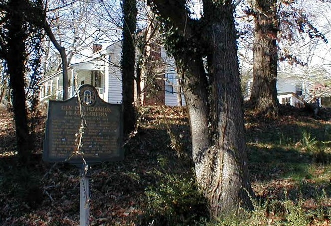
The two-bedroom
home, built by Josiah Wallis, had several uses during the Kennesaw campaign in
June 1864. It was first used as a Confederate hospital, then was the
headquarters for Union Maj. Gen. O.O. Howard. His boss, Maj. Gen. William T.
Sherman, was at the house during the Battle of Kolb’s Farm to the south.
“Adjacent to the Wallis house is Harriston Hill, which offers a
sweeping vista of the valley leading to the Confederate line atop Kennesaw
Mountain,” a National Park Service official said in 2010. “From this position,
it is clear why General Howard picked this site for his headquarters and
signaling position.”
The campaign
to save the house, give it permanent protection and have it help tell the story
of the battle during the Atlanta Campaign is a long one.
 |
| (Courtesy of GBA) |
Cobb County,
just northwest of Atlanta, for years saw an incredible housing boom and
development. While that was a boon for newcomers, preservationists and
historians decried the loss of Civil War sites or land to development.
The county,
working with the Georgia Civil War Commission and the Cobb Land Trust, spent $320,000
to buy the property in early 2004 so that 43 homes could not be built on it and
adjoining parcels, Walther told the Picket.
The park needs congressional approval in order to expand its boundaries and accept
donation of the house and hill from the county.
Several years
ago, then-Superintendent Stanley Bond helped lead a community effort to
recommend ways to increase African-American visitation to the park – and tell
the story of slaves, freed individuals, U.S. Colored Troops and more.
 |
| O.O. Howard |
Bond told the Picket in February 2011 that he hoped the Wallis House could house an expanded
exhibit on African-American soldiers and civilians. There’s a direct
connection, because of the home’s association with Gen. Howard.
Howard University, a historically black
school in Washington, D.C., was named for the white officer, founder of the
university and commissioner of the Freedmen’s Bureau.
Walther said while there currently are
no formal plans for interpretation at the Wallis House, she cited Bond’s efforts
to more fully tell the stories of African-Americans and people who lived near
Kennesaw Mountain. “We
want to tell the whole story,” she said.
The Wallis
House, near a subdivision, is just west of the main park on Burnt Hickory Road near Barrett Parkway. A paved parking lot and a sidewalk leading up to the
property line were put in several years ago.
Vegetation
has grown up around the house and while relatively structurally sound, the
residence would need a lot of work before opening. People in the community have
wanted the park to clean it up, but that could not be done because the land was
in a holding pattern until congressional action.
The
superintendent said she has been inside the structure.
“When it was
still inhabited it was a nice enough home. It’s not large, maybe 1,200 to 1,500
square feet. There are outbuildings. It has been vacant for so long it is very
dilapidated. We want to take it back to the original structure. Part of the
house is (postwar) additions. We would be ripping those out.”
The cost of restoration and other aspects of the project could be about $1 million, said Walther. “There is a lot of support to help with the renovation of the house.”
That’s considerably less than a previous $5 million estimate.
It could be five years or more before the Wallis House is open for interpretation.
First will come the submission for federal funding, which could take two to three years. “The first matter is to formulate a plan of action,” Walther said. “Funding will be the backbone of everything that will happen.”
Walther said
the staff is excited about the opportunity to provide students and others more education.
That can be done through Kennesaw Mountain’s natural and manmade features – and
the Wallis House.
“When you can
touch history, it can have a lasting impression on you.”
Monday, February 22, 2016
Archaeology at Pea Ridge: Looking beyond artifacts to show how crucial battle played out
 |
| Jami Lockhart collects magnetometry data (Credit:AAS) |
Asa Payne came
back to Pea Ridge some 49 years after the momentous Civil War battle. The
beardless boy now was a gray-bearded man in his mid-60s, living a quieter life after fighting for Emperor Maximilian I in Mexico and seeking adventures on the Santa Fe Trail.
The real
estate broker found the battlefield in northwest Arkansas to be little changed since he fought there. An
apple orchard now grew near the famous Elkhorn Tavern.
"I stayed all night in that old tavern but all was
quiet, the booming of cannon and the wails of the wounded were hushed forever,”
Payne wrote for a newspaper in Carthage, Mo., where he lived.
“I was lulled to sleep by the tinkling of cow bells in the nearby mountain and was awakened only by the hoot of owls which seemed to me were hooting their last long hoot in memory of the past."
A half
century before, this farm land trembled, sustaining the largest cannonade in
American history to that point. Green troops, led by men with untested tactics,
clashed in a battle that proved to be a disaster for the Confederacy.
 |
| Sign at Ruddick's Field (Courtesy of Jami Lockhart) |
Payne, who fought for the 3rd Missouri Infantry, wrote of the fierce scene on
Benjamin Ruddick’s cornfield just south of the tavern. About 3,000 Confederates
charged a Union position late on March 7, 1862. Union
canister and shells and infantry fire ripped through the Rebel lines. It was
over in 15 minutes, the survivors limping back toward Elkhorn Tavern.
As it was
during Payne’s return trip, Ruddick’s Field – now part of Pea Ridge National Military Park – today lies quiet and undisturbed. But recent months have seen new
activity as archaeologists have surveyed the field and prepared for excavations
beginning in March, the first time digging has taken place on the site.
Experts have a battery of technological weapons they did not
have 15 years ago, when metal detectors were used elsewhere on Pea Ridge. This
is believed to be the first time large-scale remote sensing has been used on such
a battlefield, experts tell the Picket.
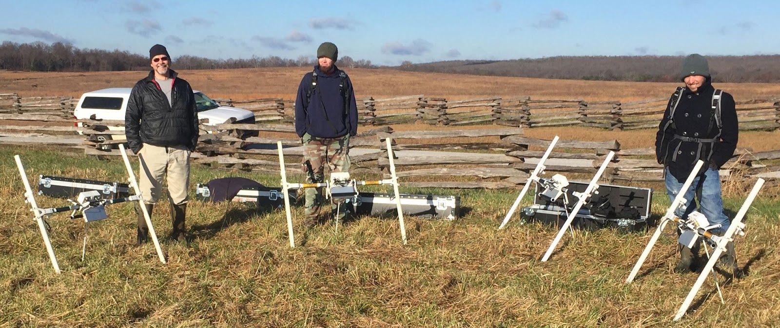
The “super precise” technology, combined with GPS maps, is
allowing archaeologists to do a complete study of a largely pristine battle
area.
“You are looking on the screen while you are walking
across the field and you know when you are standing on top” of an artifact,
said Jami Lockhart, director of remote sensing for the Arkansas Archeological Survey.
Lockhart and his Survey colleagues, working with the
National Park Service, are attempting to fine-tune the historical record of Pea
Ridge – using data and mapping to pinpoint where infantry or artillery were positioned, to follow the
trajectory of fire and see where bullets and artillery landed, often with
devastating effect.
 |
| (Courtesy of Arkansas Archeological Survey) |
“You get an
idea of where the actual lines are as they move across. With artillery, you
have aerial bursts above them. We are seeing where that is landing on the
ground,” said Steven De Vore, a regional archaeologist with the NPS.
Thousands of “magnetic anomalies” – likely artillery
shells and fragments, bullets, horse bridles, weapons parts or personal items
associated with the battle -- have been detected within two feet of the surface
at the cornfield site. Archaeologists plan to excavate a limited number for
further study and possible display at the visitor center – all part of an
ongoing effort to more fully interpret what happened here.
“The most
important thing to come out of this kind of work, by developing a clear
understanding of how that battle progressed … is to give us an opportunity to
tell us (what) our ancestors endured and what their experience was and how that
experience feeds into their later life and our collective memory,” said Carl
Drexler, a battlefield archaeologist with the Survey.
'The war was won in Arkansas'
The March
6-9, 1862, Battle of Pea Ridge (Elkhorn Tavern) has been called by some
historians “the Gettysburg of the West.”
Forces under
Union Maj. Gen. Samuel Curtis defeated the men of Confederate Maj. Gen. Earl
Van Dorn, whose leadership has been faulted by historians. On March 7, the
Rebels controlled Elkhorn Tavern, but the failed attack at Ruddick’s Field
presaged the next day, in which consolidated Federal troops made a
counterattack, sweeping Van Dorn’s brigades from the field.
The Union won
control of Missouri and weakened the Confederate hold in Arkansas.
 |
| Field is shown in map of Federal counterattack (NPS) |
“It is no exaggeration to say that the
Pea Ridge campaign permanently altered the balance of power in the
Trans-Mississippi. Few Civil War operations had such an impact on the course of
events,” according to the National Park Service.
“The
cascading effect or Pea Ridge not only locks up northwest Arkansas and
Missouri, it allows St. Louis to be base of operations for Grant’s campaigns in
Vicksburg,” said Drexler. “The war was won in Arkansas.”
Asa Payne
wrote eloquently about his experiences at Pea Ridge while just a teen.
“I remember some of our boys would laugh
and mock the shells and others were as pale as death, while still others had
great drops of sweat on their faces.”
The soldier
took part in the doomed Missouri assault on Federal troops under the command of
Col. Eugene Carr at snow-covered Ruddick’s Field. The arrival of reinforcements
and additional guns turned the tide against the Confederates led by Maj. Gen.
Sterling Price.
 |
| Eugene Carr |
"By this time it was almost dark," remembered Payne, "and we got so near the battery that the fire from the guns would pass in jetting streams through our lines."
The valiant but costly attack in Ruddick's Field late on March 7 was the high-water mark of the Confederate war effort west of the Mississippi River and the final instance in which Van Dorn held the initiative at Pea Ridge, said the NPS. “Henceforth, Curtis would control the course of the battle.”
The valiant but costly attack in Ruddick's Field late on March 7 was the high-water mark of the Confederate war effort west of the Mississippi River and the final instance in which Van Dorn held the initiative at Pea Ridge, said the NPS. “Henceforth, Curtis would control the course of the battle.”
More than 150 years later, historians and scientists are delving into the past at Ruddick's field.
“We are
seeing a massive overrepresentation of cannonball fragments to show how severe
an event this was,” said Drexler.
The artillery
duel involving 40 Federal and 30 Rebel guns speaks to the psychological and
morale toll of artillery. “The smoke and the explosion of the
cannonballs created such an overwhelming assault on the senses that the
cumulative effect … was often greater than just what the bodily destruction
was,” Drexler said.
Archaeologists
and historians over the years have benefited from the park’s remote location.
That generally means fewer postwar ground disturbances and relic hunting,
though officials remain sensitive about the latter.
Annual
visitation to Pea Ridge’s 4,300 rolling hills and fields is about 120,000, said
Superintendent Kevin Eads. “That is the beauty of the park. It is extremely
well-preserved.”
The Arkansas
Archeological Survey, a part of the University of Arkansas system, expects the
four-year Pea Ridge project to study up to nine areas on the federal property.
Officials hope to operate a field school at Leetown, which contains foundations
of buildings at a hamlet that existed during the battle.
“I think this
project will give us some amazing information,” Eads told the Picket.
 |
| Pea Ridge's Elkhorn Tavern (NPS) |
High-tech gadgets take to the field
The Survey is
“very cutting edge in high-tech technology,” said
Jamie Brandon, a regional archaeologist on the team.
Excavations at Pea Ridge in 2003 and earlier used
traditional methods, including metal detectors and cordoned strips.
“This is the first time we will use these
high-tech ways of looking at the ground before we dig, Brandon said.
Visitors to
Pea Ridge in recent months have seen archaeologists using H-shaped magnetometers
to peer beneath the surface of the cornfield’s 22 acres.
Researchers have
employed five remote-sensing technologies for this project: Gradiometers, electrical
resistance, electromagnetic conductivity, magnetic susceptibility and
ground-penetrating radar. The effort will be supplemented by the traditional
metal detector during small, pinpoint excavations this spring.
 |
| Earl Van Dorn |
“Each senses
a different physical property in the soil,” said Lockhart, the technology guru
of the team. “We are trying to determine, because we can sense big
concentrations of metal … where troops were shooting from and to.”
He and others
speak of what makes this project particularly interesting. Rather than sifting
through pottery sherds, shed foundations or wall fragments, they are “tracking”
thousands of pieces of metal in a moving battle. Brandon likens it to the power
of Doppler radar.
De Vore, with
the National Park Service, said the benefit of this type of field survey is
clear: Metal detectors leave gaps. “The advantage right now with doing the
magnetic survey in large, open area is we can cover the ground with really good
coverage. We are not missing a lot.”
“Plus, it
gives you a map of display of where things are located,” he said. “You get a
pattern of what is going on.”
Researchers,
for example, can better see the radial patterns of shell bursts. “You will have
dropped bullets. You can find how lines are progressing,” said De Vore. “You
can find out where other infantry is firing on, where the bullets landed.”
Filling in personal stories
Eads, the superintendent,
said discoveries at Ruddick’s Field and elsewhere at the park will help the NPS
make management decisions and tweak interpretation of the battle, if necessary.
“The
Officials Records may say one thing and we find something that is inconsistent
or dead-on.”
The visitor
center was redone a few years ago, complemented by some new exhibits. But
officials hope many recovered artifacts will go on display.
“We have a
few items from the field, but not very many,” said Eads. “Most are
reproduction. We hope to bring in more of these artifacts on a rotational
basis.”
 |
| Autumn scene at Pea Ridge (NPS) |
Make no mistake:
Archaeology can help shape the telling of history.
More than
decade ago, Drexler worked with NPS archaeologist Douglas Scott at Little
Bighorn, where Lt. Col. George Armstrong, a Civil War hero, and much of the 7th
Cavalry met their doom in 1876. Scott’s research showed movement of the
regiment’s companies and the breakdown of command and control during the Indian
attack.
“Soldiers are
trained to behave in a certain way on the battlefield,” said Drexler. From
well-ordered lines “you can see points where those lines become jumbled,
erratic movement that is indicative of when the men start to panic, run in ways
inconsistent with their training.”
Drexler said
remote sensing can show “disturbance” features, including possibly burial areas
or shell depressions in Ruddick’s Field. The shape of a crater can show the
location of the battery that fired a round.
“You are
going to find things. A metal detector will key on artifacts,” he said. “It
will not show a disturbance of soil that may be a result of human impact, such as
a furrow from shell impact.”
The
archaeologist gave examples of previous discoveries:
-- Experts
found evidence of a Colt revolving rifle used at Leetown.
-- At Wilson’s Creek battlefield in Missouri, archaeologists did not find civilian
ammunition, despite a widespread belief that Confederates grabbed rifles off
the fireplace mantle in order to shoot Yankees.
-- Experts proved that an artillery battery
with a 24-pound howitzer was in fact at Pea Ridge. And they determined the
Federal army salvaged parts of Enfield and Springfield rifles, rather than
obsolete weapons.
 |
| (Courtesy of Arkansas Archeological Survey) |
Of course, until
the first shovel turns earth at Ruddick’s Field, no one knows for sure whether
any part of Pea Ridge’s story will be rewritten.
“There
probably is going to be a fair number of bullets. I expect there to be
literally buckets of shell fragments given the artillery duel focused on the
north edge of the field," said Drexler. "Possibly a few weapons parts and personal items.” If human
remains are found, there could pieces of equipment – such as buttons -- that
came off over time.
Drexler spoke
of battle descendants who have conducted genealogical research. “Their
connections are strong and emotional.”
“By helping
the park present the battle accurately, when people will come with a personal
story, they can sense this landscape is important and (possibly the location)
of the final act of that ancestor’s life.”
Tuesday, February 16, 2016
Road may be named for black soldier
Inspired by
South Carolina pulling the Confederate flag from the front of its Statehouse, an effort by Washington state lawmakers to remove a symbol of
slavery passed the House unanimously Monday. House Joint Memorial 4010,
which heads to the Senate for consideration, would name Highway 99 after black
Civil War veteran William P. Stewart of Snohomish. • Article
Thursday, February 11, 2016
Gettysburg: A trip down memory lane

Subscribe to:
Posts (Atom)