Showing posts with label st. louis. Show all posts

Monday, April 17, 2023

Gettysburg unveils bronze markers that feature braille, 3D landscapes. The idea came from a giant map that has aided park guides for generations.

New tactile marker at Virginia Memorial includes braille (click to enlarge, GNMP)
Three new Gettysburg National Military Park markers – featuring landscape elevations that visitors are encouraged to touch – were inspired by a massive topographic map created more than a century ago and on display at the park’s visitor center.

Park officials on Friday said two bronze relief tactile tables have been installed at key tour spots and another is on the way. The three-dimensional tables feature braille and raised lettering, making them the first such additions to the park.

“Visitors will now have access to better understand the landscape across which the battle was fought and how terrain influenced the movements of the two armies at Gettysburg in July of 1863,” the park said in a news release.

One table is on the plaza at the Virginia Memorial (Auto Tour Spot 5, photo at left) and other at the National Cemetery parking lot (Auto Tour Spot 16). Another is coming soon to the Eternal Light Peace Memorial (Auto Tour Spot 2).

Gettysburg spokesman Jason Martz told the Picket in an email that visitors who are visually impaired can read them by touching the table and its key. “The raised lettering, along with the braille, allow those with visual impairments to gain a better appreciation for the park landscape,” he wrote.

Martz said the idea for the three tables was based on a giant relief map of the battlefield produced by Emmor B. Cope, an engineer who was at the battle and returned a few months later to help survey the ground.

Cope was instrumental in the creation of numerous battlefield monuments and features and was the park’s first superintendent.

His bronze relief map -- 12.5 feet by 9.5 feet and 4 inches deep – is considered an indispensable tool for historians of the early battlefield, according to the Gettysburg Daily website.

It was displayed at the 1904 St. Louis World’s Fair. It includes tiny buildings and avenues that were built after the war. The map created by Cope (right) was laid flat at St. Louis and at the old Cyclorama building at Gettysburg; it is now propped vertically against a wall near the bookstore at the Gettysburg visitor center.

Park ranger Troy Harman, in a 2021 video posted on Facebook, explained why he considers the incredibly detailed Cope map to be the most important artifact at Gettysburg.

“It has always fascinated me and I have relied on it heavily in doing programs on the battlefield because it is so meticulous in its design and its precision of the Gettysburg battlefield.”

Since the Cope map caught a moment in time – when Cope and others surveyed the battlefield soon after the battle -- historians and others can turn to it to see what the area looked like before development and park features altered the landscape.
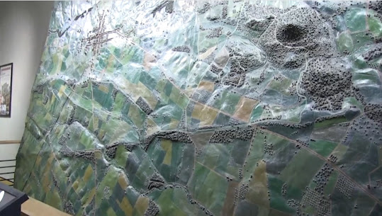
The behemoth Cope relief map in the visitor center (GNMP)
“If you want to see what the ground was originally like, come back to this map,” Harman said. “The ground is pristine, as it looked like at the time of the battle.”

Speaking of the much smaller tactile tables, Martz told the Picket the elevations were taken from existing GIS maps and further refined by utilizing historical information from the Cope map and others made by those working for Maj. Gen. Gouverneur Warren, chief engineer for the Army of the Potomac.

The three tables were created by Pannier Graphics and cast at an American Bronze foundry.

The creation of the tactile tables is part of a larger project to update interpretive signage throughout the park, officials said.

New tactile table in parking area of Gettysburg national cemetery (GNMP)

Monday, April 18, 2022

A story of resilience: County park in Missouri will bear name of former slave who fought in Civil War, became a successful farmer on site

Council officials with Benjamin Oglesby descendants at recent meeting (St. Charles County)
A suburban St. Louis family is grateful and proud that a future park will be named for a former slave who fought for the Union during the Civil War and later successfully farmed on the site for 30 years.

The St. Charles County Council in Missouri last week approved the honor for Benjamin Oglesby, who fled captivity at age 39 and joined the 56th US Colored Infantry Regiment.

The 199-acre Oglesby Park, just west of Wentzville and near Interstate 70, will include playgrounds, paths and shelters, county officials said. It is expected to open in July.

“We will have signage telling his story and we may even be relocating a 1920s Black school to the property, that was operated by the church where Mr. Oglesby and his family attended and sits on the same property where Mr. Oglesby and his wife are buried,” said Ben Gall, park historian.

In a press release, County Executive Steve Ehlmann said, “The history behind landowner Benjamin Oglesby and his family is both remarkable and inspirational.”

Gall said his research showed that Oglesby was born in Bedford, Virginia, about 1825. In the mid-1830s, he came to St. Charles County with his enslaver Marshall Bird. The farm near Foristell grew corn, wheat and tobacco.

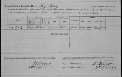
In November 1864, Oglesby enlisted in the U.S. Army and was sent to Benton Barracks in St. Louis for training. He was assigned to the 56th USCT, which conducted military operations in Arkansas, including fighting at the Battle of Big Creek. The regiment also fulfilled post and garrison duty (One of Oglesby's military records at left).

Oglesby was honorably discharged in November 1865, outside Helena, Arkansas, Gall said.

Records kept by the National Archives showed receipt of a $33.33 bounty when Oglesby was mustered into service at Benton Barracks. Some $66.67 was due.

Gall said Congress instituted a February 1864 draft that included Black men who lived in Border States such as Missouri. “Loyal slaveowners” would be paid bounties for slaves who were freed and brought in the Army.

While there are no definitive records in Oglesby’s case, Gall told the Picket, it seems the bounty was due to the former slave because “his file does not contain any records of Bird filling out the loyalty oath and bounty … Recently freed Black soldiers did receive the bounty payment if their owner was not considered loyal.

The park site is just a couple miles north of I-70 (St. Charles County)
More than 180,000 African-Americans served in the U.S. military during the Civil War.

After the Civil War, according to the 1870 census, Oglesby, his wife, Martha and their six children -- Medora, Samuel, Oskar, Bell, Albert and Charlie -- worked on a farm in Hickory Grove Township in Warren County, officials said. In 1871, he purchased 146 acres of land in Foristell. He financed the property through a $2,000 deed of trust and paid off the property six years later.

“When Mr. Oglesby died in 1901, the estate records indicate a nearly 50% increase in the value of his property, demonstrating him as a successful farmer,” Gall wrote in an email. “The property was still in the family through the 1960s.”

There are no known photographs of Oglesby.


Barbara Love, the soldier’s great-great-granddaughter, told St. Louis TV station KMOV that her ancestor was determined to succeed after escaping slavery.

“He wanted to do something, not just for him, but for family,” she said. “To say I’m a descendant of Benjamin Oglesby is a blessing.”

Love wrote on Facebook that her ancestor's story shows "you can be anything you want if you keep the faith."

Enlistment information for Benjamin Oglesby (click to enlarge, National Archives)
When the park property was purchased at the end of last year, Gall was tasked with conducting research on the originally proposed name for the park, which is located at 2949 West Meyer Road. 

“When looking at the 19th century maps of the property, I saw the name Benjamin Oglesby was marked as the owner of the property and decided to do a little digging just to see who he was,” Gall wrote.

“The research revealed a truly remarkable story of resilience, so I provided the name and research to my supervisors for consideration. The director of the department, who is a fellow historian, also found the story remarkable and decided to officially propose it. When we learned there were descendants still active in the community, it seemed to show this was meant to be.” 

(Courtesy of St. Charles County)

Friday, March 16, 2012

Guilty plea in theft of coins

A former tour guide at the Museum of Transportation in St. Louis was ordered to serve three years of probation after pleading guilty to stealing six Civil War-era coins valued at $18,844. • Article

Tuesday, March 15, 2011

St. Louis event will recall bloody riot

Plans for local events to observe the 150th anniversary of the Civil War were rolled out Monday during a ceremony at the Missouri History Museum in St. Louis. • Article