 |
| New tactile marker at Virginia Memorial includes braille (click to enlarge, GNMP) |
Park
officials on Friday said two bronze relief tactile
tables have been installed at key tour spots and another is on the way. The
three-dimensional tables feature braille and raised lettering, making them the
first such additions to the park.
“Visitors
will now have access to better understand the landscape across which the battle
was fought and how terrain influenced the movements of the two armies at
Gettysburg in July of 1863,” the park said in a news release.
One table is on the plaza at the Virginia Memorial (Auto Tour Spot 5, photo at left) and other at the National Cemetery parking lot (Auto Tour Spot 16). Another is coming soon to the Eternal Light Peace Memorial (Auto Tour Spot 2).
Gettysburg
spokesman Jason Martz told the Picket in an email that visitors who are
visually impaired can read them by touching the table and its key. “The raised lettering, along with the braille, allow those with visual impairments to gain a better appreciation for
the park landscape,” he wrote.
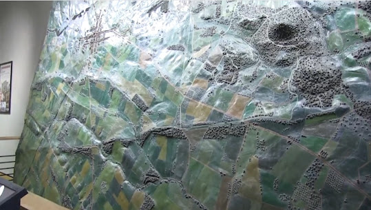
Martz said the idea for the three tables was based on a giant relief map of the battlefield produced by Emmor B. Cope, an engineer who was at the battle and returned a few months later to help survey the ground.
Cope was instrumental in
the creation of numerous battlefield monuments and features and was the park’s
first superintendent.
His bronze relief
map -- 12.5 feet by 9.5 feet and 4 inches deep – is considered an indispensable
tool for historians of the early battlefield, according to the Gettysburg Daily website.
It was displayed at the 1904 St. Louis World’s Fair. It includes tiny buildings and avenues that were built after the war. The map created by Cope (right) was laid flat at St. Louis and at the old Cyclorama building at Gettysburg; it is now propped vertically against a wall near the bookstore at the Gettysburg visitor center.
Park ranger
Troy Harman, in a 2021 video posted on Facebook, explained why he considers the
incredibly detailed Cope map to be the most important artifact at Gettysburg.
“It has
always fascinated me and I have relied on it heavily in doing programs on the
battlefield because it is so meticulous in its design and its precision of the
Gettysburg battlefield.”
Since the Cope map caught a moment in time – when Cope and others surveyed the battlefield
soon after the battle -- historians and others can turn to it to see what the
area looked like before development and park features altered the landscape.
 |
| The behemoth Cope relief map in the visitor center (GNMP) |
Speaking of
the much smaller tactile tables, Martz told the Picket the elevations were
taken from existing GIS maps and further refined by utilizing historical
information from the Cope map and others made by those working for Maj. Gen. Gouverneur Warren, chief engineer for the Army of the Potomac.
The three tables
were created by Pannier Graphics and cast at an American Bronze
foundry.
The creation of the tactile tables is part of a larger
project to update interpretive signage throughout the park, officials said.
 |
| New tactile table in parking area of Gettysburg national cemetery (GNMP) |


No comments:
Post a Comment