Showing posts with label beach. Show all posts

Saturday, January 31, 2026

Of hapless blockade runners and the 'Stone Fleet' that failed to stop them: Beach restoration project near Charleston will safeguard ill-fated historic shipwrecks

Recent beach work (City of Isle of Palms), wreck of Constance (SCIAA) and sinking of "Stone Fleet" (Courtesy MIT Museum)
The latest effort to fight beach erosion and restore dunes along a barrier island near Charleston, S.C., will work around the wrecks of three Confederate blockade runners and whaling ships the Union navy sank in an effort to prevent the merchant vessels from reaching the city.

The city of Isle of Palms and state archaeological and preservation offices are developing buffer zones around the sites in preparation for dredging this year, officials said. The goal is for dredgers to pick up sand a couple miles off the coast and bring it ashore for beach nourishment.

“This project will protect our history and our shoreline for the 4,000+ residents that call our Island home and the 20,000+ visitors that enjoy our beach every day in the summer,” the city said in a recent social media post.


Scores of blockade runners tried to reach Charleston during the Civil War, but many ran aground off the Isle of Palms and nearby Sullivan’s Island. Shoals and shallow water, along with fire from Federal ships and batteries, were a constant danger.

The three blockade runners in the project area – the Georgiana, Mary Bowers and the Constance – are near the remains of what were called “Stone Fleets.”

In late 1861 and early 1862, 29 whaling and merchant vessels brought from the Northeast were deposited in the channels leading into Charleston. The idea was to hinder blockade runners who ran the extra risk of slamming into ship timbers, sand bars or stones carried in the hulls. Ships often carried stones to give them stability, improved handling and a lower center of gravity.

SCIAA graphic shows blockade runners and "Stone Fleet" areas below, above city
“The Stone Fleet’s efficacy was almost immediately diminished by the force of the natural scouring of tides as the redirected tidal waters of the harbor made new channels,” according to the South Carolina Institute of Archaeology and Anthropology (SCIAA). Most of the wrecks were dispersed by currents and shifting sand.

South Carolina underwater archaeologist Jim Spirek said while the $32 million project will encompass the three blockade runners, “the location of the current proposed borrow area is our attempt to deflect encroachment on the nearby Stone Fleet vessels.”

While the strategy was ultimately ineffective, Stone Fleet wrecks remain important cultural sites today, the city said. Ballast mounds are still visible by side-scan survey.

Beach nourishment areas in blue (City of Isle of Palms)
Dredging is anticipated to begin late spring or early summer. Sand will be placed along three placement areas, which include homes, beach access areas and the site of a playground.

The Picket has reached out to city officials for comment but has not heard back.

Wrecks 'disappeared' at nearby island

Over the years, Spirek and his colleagues have surveyed and/or dived on many blockade runner and “Stone Fleet” wrecks.

While the whereabouts of many are known, the state wanted to know more about four that are no longer visible off Sullivan’s Island. Spirek’s office last years used drones to conduct a survey of the “forgotten” wreck sites.

The remains of those vessels are are now buried deep below the beach and adjacent woodlot.

'Stone Fleet" ballast mound captured by sonagram (City of Isle of Palms)
The planned beach nourishment at the Isle of Palms has prompted Spirek to advise the State Historic Preservation Office on how to safeguard the sites.

In a case like this, “typically we propose a buffer zone around the sites to protect them from dredging and other ancillary activities, i.e., anchoring, cables,” the archaeologist said in an email to the Picket.

Bad luck be a baby for three runners

Spirek has written numerous articles about the history of these vessels and the bad luck they encountered.

That history begins with the Union blockade strategy


As the Union’s nautical noose tightened around Charleston, blockade runners daring to bring vital goods to the Confederacy typically took the shortest route into the harbor, sailing close to Fort Moultrie on the southwestern tip of Sullivan’s Island. They typically sailed through Maffitt’s 
(or Beach) Channel.

Many did not make it, or get back to sea safely.

The Georgiana, Mary Bowers and the Constance were among the victims. Interestingly, they lie together because two ran into the wrecks of the other, the state says. We’ll explain

Georgiana: The Scottish-built ship may have been intended for military service or privateering. After picking up goods in the Bahamas, it sailed to Charleston, arriving on March 18, 1863. Federal gunner’s spotted the Georgiana in Maffitt’s Channel and crippled it. The crew abandoned the ship, according to an American Battlefield Protection Program report by Spirek. Union ships pulverized the ship and set it afire. Over the following days, Union crews salvaged various items from the wreck including Enfield rifles, bayonets, battle axes, sabers and other sundry goods.

Captains of "Stone Fleet" vessels that left New Bedford, Mass. (New Bedford Free Public Library)
Mary Bowers: This runner that stopped in Bermuda tried to enter Charleston Harbor on Aug. 31, 1864, but it struck Georgiana. It quickly sank. “Union sailors found a 16-year old boy aboard who told them he knew of no cargo other than coal, and that the steamer was to leave laden with cotton bound for Halifax, Canada.”

Constance: The side-wheeler sailed from Nova Scotia, struck the Mary Bowers on Oct. 6, 1864, and quickly sank. One sailor drowned. The next morning, USS Wamsutta reported a strange wreck lying near the wrecks of Georgiana and Mary Bowers. Casting anchor, the blockader investigated the wrecked vessel, which had two smokestacks and masts, sidewheels, lying in three fathoms of water.

State officials believe the three wrecks were near the area of the "Second Stone Fleet.”

Examples of "First Stone Fleet" ballast left on ocean floor (SCIAA)
“While the Second Stone Fleet effectiveness as a deterrent to using the Maffitt’s/Beach Channel to enter Charleston Harbor may have been marginal, the presence of the sunken vessels along with the floating vessels, made any voyage through the blockade at Charleston Harbor potentially disastrous,” a report asserts.

All three wrecks were located in the late 1960s and 1970. Numerous items were removed in licensed, private salvage operations. Sports divers later recovered artifacts from the Mary Bowers and Georgiana.

Postscript: Melville's ode to the doomed ships

Right before I published this post, I came across a December 1861 poem about the doomed “Stone Fleet” vessels by acclaimed author Herman Melville. Some of the old ships were sent to the Savannah River in Georgia to blockade enemy ships.

Melville paid tribute to them in “An Old Sailor’s Lament.”

  I have a feeling for those ships,
    Each worn and ancient one,
    With great bluff bows, and broad in the beam:
    Ay, it was unkindly done.
        But so they serve the Obsolete--
        Even so, Stone Fleet!

    You'll say I'm doting; do you think
    I scudded round the Horn in one--
    The Tenedos, a glorious
    Good old craft as ever run--
        Sunk (how all unmeet!)
        With the Old Stone Fleet.

    An India ship of fame was she,
    Spices and shawls and fans she bore;
    A whaler when the wrinkles came--
    Turned off! till, spent and poor,
        Her bones were sold (escheat)!
        Ah! Stone Fleet.

    Four were erst patrician keels
    (Names attest what families be),
    The Kensington, and Richmond too,
    Leonidas, and Lee:
        But now they have their seat
        With the Old Stone Fleet.

    To scuttle them--a pirate deed--
    Sack them, and dismast;
    They sunk so slow, they died so hard,
    But gurgling dropped at last.
        Their ghosts in gales repeat
        Woe's us, Stone Fleet!

    And all for naught. The waters pass--
    Currents will have their way;
    Nature is nobody's ally; 'tis well;
    The harbor is bettered--will stay.
        A failure, and complete,
        Was your Old Stone Fleet.

Tuesday, February 4, 2025

Escaped Rebel officers came ashore at this remote Virginia beach. A new marker tells the story -- but you need to earn the view by a long walk in state park

Jason Saffer adjusts Va. marker (Civil War Trails) and Florida wreckage of Maple Leaf (at left, Library of Congress)
Most of Civil War Trails’ 1,530 markers are just a short walk from a parking lot. But there are many you have to work a little harder to reach.

For example, you must ride a boat to see one on St. Clement’s Island in the Potomac River or take a rigorous hike along the Appalachian Trail to soak in others.

Now the Williamsburg, Va.-based nonprofit has erected a marker in likely its most remote location, says executive director Drew Gruber.

Virginia State Parks announced last week the addition of the new panel at False Cape State Park below Virginia Beach. To get there, pedestrians or bicyclists must venture six miles beyond a parking lot, over a dune, past a primitive campground and head for the Atlantic Ocean surf.

Visitors will learn about how Confederate officers overcame unarmed guards on the Maple Leaf transport ship in 1863, escaped and eventually made their way to friendly lines.

“People have already been making the trek,” Gruber told the Picket. “Besides hiking to the site where these POWs landed you can also take a tram tour ...”

Star shows location of marker and trail map shows proximity to camping area, ocean (Civil War Trails, Va. State Parks)
The escape from the Maple Leaf is labeled as a point of interest on the park’s trail map.

“Now having a physical marker at the location enables us to preserve the Civil War history of False Cape and lets park guests explore learn, and embrace the lessons of courage and unity from this daring account,” said Rachel Harrington, chief of visitor experience at the park, in the news release.

Not everyone breaks a sweat to reach the marker. Harrington told the Picket a tram the park operates features a four-hour guided tour. The open-air Blue Goose Tram goes fairly close to the site of the landing and informs participants of the Civil War history.

The Civil War episode took place in June 1863, when 97 captured Rebel officers were being taken on the vessel Maple Leaf from Fort Monroe, Va., to Fort Delaware, then to a Northern prison camp. They quickly took control of the transport ship from 12 soldiers carrying unloaded muskets.

They did not have enough coal to flee to the Bahamas and after sailing south for about 30 miles some 70 officers decided to land small boats on what is now the state park, said Harrington. (About 27 captives stayed on board)

The soldiers split up and headed toward friendly lines in nearby North Carolina. Despite heavy Union cavalry pursuit and the challenges of the Great Dismal Swamp, they rendezvoused in Weldon, N.C., before taking a train to Richmond, Va. Local sympathizers gave them a hand during their odyssey.

“After a 12-day journey, the officers arrived in the Confederate capital, where they told tales of their bold feat,” the marker reads. “After resting and receiving back pay, they returned to their units.”

The Maple Leaf returned to Federal service but ran into more bad luck in April 1864 when it struck a torpedo in the St. Johns River near Jacksonville, Fla.

“The explosion tore the bow of the ship apart, ripping through the deck and killing four soldiers," according to the National Park Service. “The vessel sank quickly, but apart from those lost in the explosion there were no other fatalities.

The shipwreck was not salvaged, but  thousands of artifacts were recovered in the 1980s and 1990s. Many are on exhibit at the Mandarin Museum nearby.

Civil War Trails
promotes tourism, working with local governments, parks and visitor bureaus. It has another sign about the Maple Leaf below Currituck, N.C.

Virginia Beach tourism leaders hope the Maple Leaf marker and other attractions will help draw tourists to the Sandbridge area near the North Carolina border during the offseason.

False Cape State Park features about six miles of beaches. (At right, park manager Austin Monnett and chief ranger Rachel Harrington.) It offers guided kayak trips, primitive camping, interpretive programs, hiking and biking trails

Public vehicular access at the state park is prohibited. Visitors should park at Back Bay National Wildlife Refuge's parking lot at 4005 Sandpiper Road, Virginia Beach, to begin their hike or ride and to reach the visitor center. The cost to park is $5. Tram tours cost $8 and require a reservation. They operate year round, but run more frequently from April through October. Click here for more information.

Friday, September 8, 2023

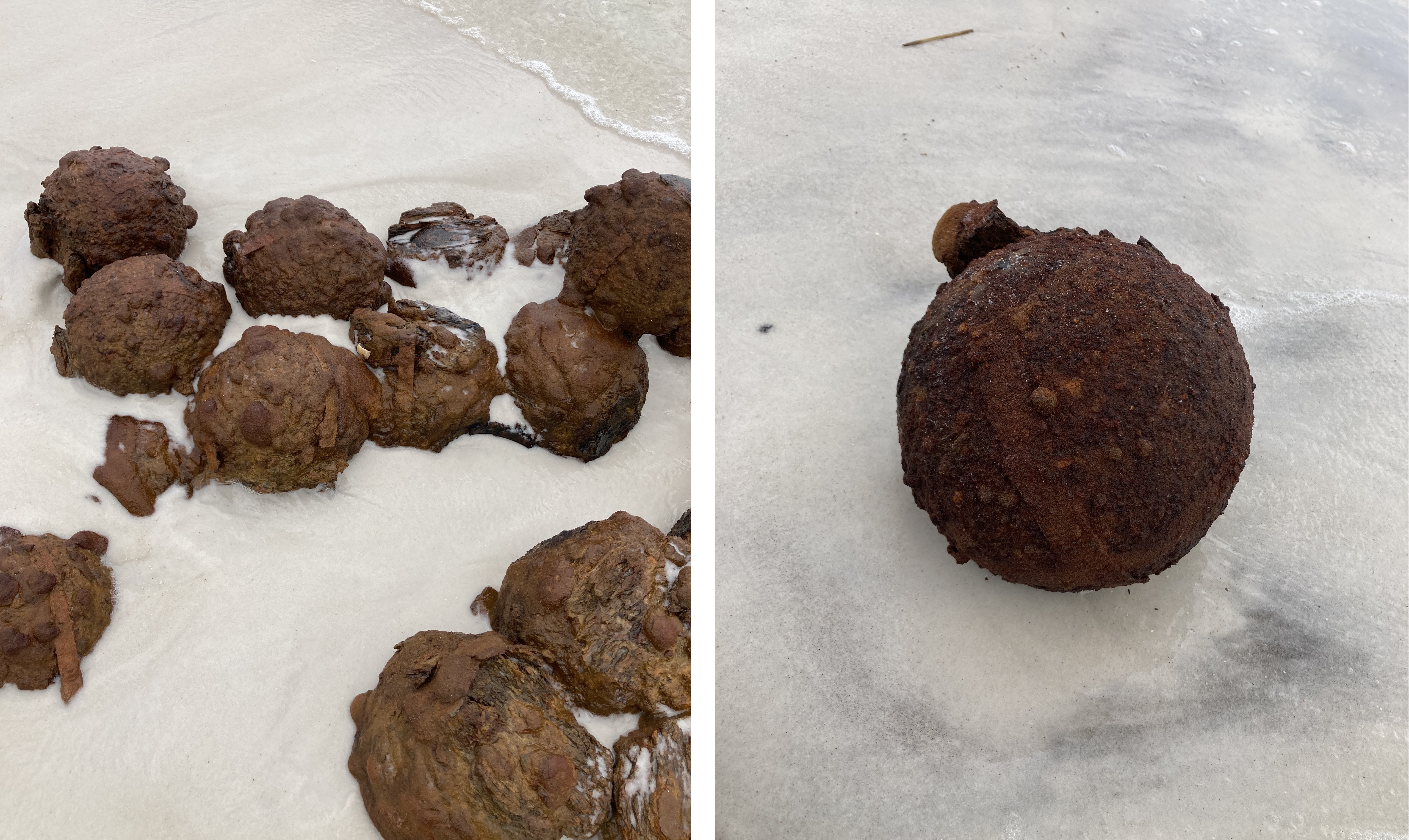
A hurricane unearthed cannonballs on Florida Panhandle beach. It looks like Confederates had stacked them, on what was then dry land

Shells were neatly stacked and have D-shaped tong holes (Gulf Islands National Seashore)
Federal archaeologists have found more evidence that scores of eroding cannonballs found in 2021 along a beach in the Florida Panhandle were Confederate, officials said.

The Picket recently asked Gulf Islands National Seashore for an update on the shells, which were in vicinity of the Civil War’s Fort McRee. The fort had 12 casemates and an associated water battery, which may be underwater today.

“The (mortar) rounds appeared to have been stacked and had corroded into a single mass at the time of their discovery,” said Mike Lockman, cultural resource program manager and archaeologist at the park, in an email. “The shells exhibited D-shaped tong holes on either side of the fuse plug, indicating that they were likely Confederate rounds (as Union mortar shells usually lacked this feature, per Bartleson 1972).”

The fuse specimens were wooden plugs with timed paper fuses. Also present were wood fragments with curved indentions that were most likely sabots, Lockman said.

When news of the August 2021 find came out, the park said 194 rounds were located. The more recent details list 53 8-inch mortars -- which were destroyed on
site by experts from the Air Force’s Hurlburt Field -- because they were intact and observed to have fuses, Lockman said. (At right, shells lined up for demolition)

The Picket could not determine whether the 53 are a subset of the larger number.

Two months after the discovery, archaeologists from the National Park Service’s Southeast Archeological Service returned to Perdido Key to learn more about the artillery rounds, Lockman said. The Picket reached out to that Tallahassee-based office for comment, but has received no reply.

The exposed ordnance was discovered by Gulf Islands National Seashore staff after Category 4 Hurricane Ida pushed through in late August 2021. The artifacts were found in clusters and the area was closed for a time as a precaution.

Soldiers at Fort McRee, year unknown (Gulf Islands National Seashore)
It’s likely the cannonballs are associated with Fort McRee, which was built on a narrow barrier island separating Pensacola Bay and the Gulf of Mexico.

In November 1861, the garrison engaged in gunfire with nearby Union-held Fort Pickens and a couple warships -- and came up on the losing end. The heavily damaged brick fort, built on sand, was abandoned by May 1862, only to fall into further ruin over the years. (Fort Pickens was one of only four Southern forts to remain in Union control throughout the war.)

In 2022, the park said some of the cannonballs utilized Hotchkiss timed fuses. “Due to the threat to life and health associated with live munitions, the cannonballs had to be destroyed before much specific information could be recorded,” said public information officer Susan Teel.

(Gulf Islands National Seashore)
Asked whether the cannonballs were discarded by the garrison or had been stored there for possible future use, Teel said last year: “Without the ability to safely complete excavations, the purpose behind the location is not known at this time. The density and location within the vicinity of the fort is a factor which was considered during our analysis.”

It's possible that Federal occupiers of the abandoned fort stacked the Rebel shells and left them at some point. The ordnance each weighed between 25 and 35 pounds and are believed to be of the same type, officials have said.

Erosion regularly occurs on these barrier islands and park officials say the ordnance was likely placed in a spot that was inland at the time.

1928 view of battery on island. Fort McRee was built close by. (National Archives)
Park Superintendent Darrell Echols told WEAR-TV that the artifacts appeared to have been stockpiled and did not appear to have been fired upon the island. After the Picket posted its first article about the find on social media, readers commented they believe the ordnance was made for a 32-pounder cannon.

Inaccessible by road, McRee’s main visitors are sea birds, boaters and beachgoers who come to Gulf Islands National Seashore. The park is home to McRee, Pickens and Fort Barrancas, another Civil War outpost.

Lockman said it’s possible the artillery shells will be further investigated.

Friday, April 1, 2022

Mystery along the beach: Archaeologists continue research after 2021 discovery of 194 Civil War-era cannonballs in Florida Panhandle

Shells were found Sept. 3-5 and 21-23, 20201  (Gulf Islands National Seashore)
National Park Service archaeologists are awaiting a more detailed analysis of 194 cannonballs found last year along a beach at a federal park in the Florida Panhandle. Thus far, there are more questions than answers about the artillery shells.

The ordnance was discovered by Gulf Islands National Seashore staff after Category 4 Hurricane Ida pushed through in late August. The artifacts were found in clusters and the area was closed for a time as a precaution.

It’s likely the cannonballs are associated with nearby Confederate Fort McRee, which was built on a narrow barrier island separating Florida’s Pensacola Bay and the Gulf of Mexico.

In November 1861, the garrison engaged in gunfire with nearby Union-held Fort Pickens and a couple warships -- and came up on the losing end. The heavily damaged brick fort, built on sand, was abandoned, only to fall into further ruin over the years.

The Picket this week reached out to the park for an update on the discovery.

Soldiers at Fort McRee, year unknown (Gulf Islands National Seashore)
“The cannonballs were spherical shot, some of which utilized Hotchkiss time fuses,” public information officer Susan Teel wrote in an email. “Fort McRee was under Confederate control during the Civil War, but the cannonballs could not be determined if they were cast by one side or the other. Due to the threat to life and health associated with live munitions, the cannonballs had to be destroyed before much specific information could be recorded.”  

Asked whether the cannonballs were discarded by the garrison or had been stored there for possible future use, Teel said: “Without the ability to safely complete excavations, the purpose behind the location is not known at this time. The density and location within the vicinity of the fort is a factor which was considered during our analysis.”

The shells weighed between 25 and 35 pounds and are believed to be of the same type, Teel said last September. “They are hollow, potentially black powder filled cannonballs considered discarded military munitions.”

Cannonballs likely were further inland during the Civil War (GUIS)
Erosion regularly occurs on these barrier islands and park officials say the ordnance was likely placed in a spot that was inland at the time.

Superintendent Darrell Echols told WEAR-TV that the artifacts appeared to have been stockpiled and did not appear to have been fired upon the island. WEAR reported the cannonballs were found about a half mile from Fort McRee.

McRee had 12 casemates and an associated water battery, which may be underwater today. Virtually nothing remains today, with the exception of part of the fort's foundation. (After the Picket posted its first article about the find on social media, a few readers commented they believe the ordnance was made for a 32-pounder cannon.)

Inaccessible by road, McRee’s main visitors are sea birds, boaters and beachgoers who come to Gulf Islands National Seashore. The park is home to McRee, Pickens and Fort Barrancas, another Civil War outpost.

Teel said the NPS’s Southeast Archeological Center documented the cannonballs before they were detonated on site by experts from the Air Force’s Hurlburt Field (right).

NPS archaeologists returned in early October to see what else may be in the area. Echols told WEAR at the time that based off the survey, there's little reason to believe more cannonballs could be in the area.

"No other cultural materials (anything made or altered by human hands) were located during the survey of the area," Teel wrote this week. "The Southeast Archeological Center did complete a comprehensive survey which included excavations around the munitions, due to the hazards associated with live ammunitions."

Teel said of the project:

“Preservation is crucial for our mission and our interest, however never as important as a person’s life. While citizens love to help preserve and protect our history, it is illegal to search for artifacts on federal property, and more importantly can be extremely dangerous.”