 NOAA, in an article released Tuesday, provides details of the survey work of Coast Survey Assistant Ferdinand Gerdes, who it calls one of the unsung heroes of the Civil War.
Gerdes was employed by the U.S. Coast Survey, predecessor of NOAA.
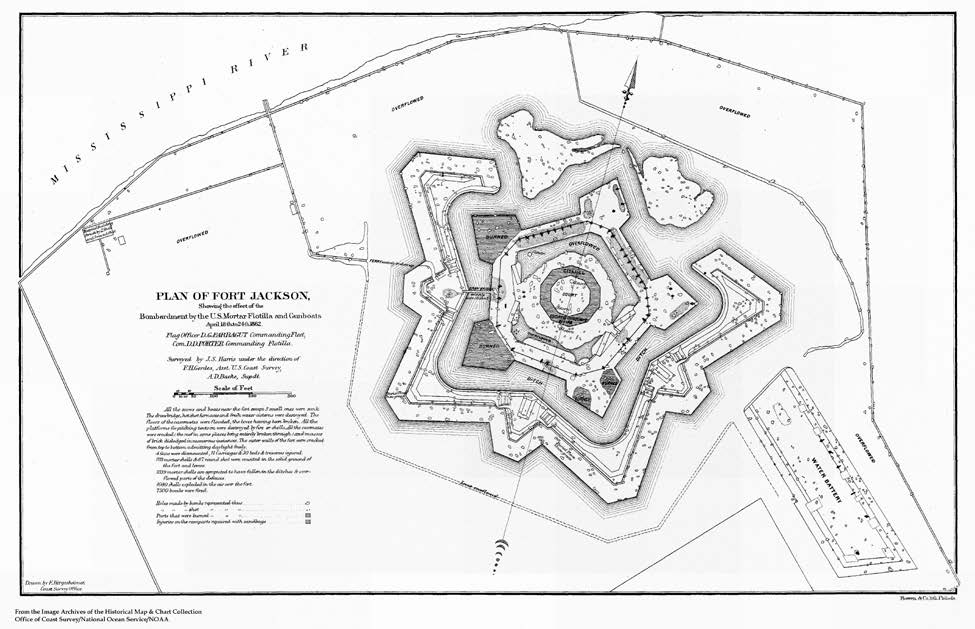
Fort Jackson and Fort St. Philip, two Confederate forts essential to New Orleans’ defense, were located on opposite sides of the Mississippi 70 miles south of the city. Commander David Dixon Porter (below) got permission to damage their guns.
"By relying on mathematical calculations — using survey coordinate points established by Coast Survey teams, rather than judging distance by sight — Gerdes would give coordinates to Union flotilla gunboats so they could aim their weapons without seeing the target," NOAA said.
 Gerdes' team, under fire, established survey markers on the shore and made maps and charts. They measured a series of small triangles.
On April 18, 1862, Union boats began their attack on Fort Jackson. Over the next six days, an estimated 4,000 mortar shells rained on the fort.
"When the Confederates discovered where the shells were coming from and started firing back, the boats would have to move, which meant additional surveying — again, often under fire," according to NOAA.
WIth the help of damaging bombardments, the Union fleet, which included 6,000 troops, under Adm. David Farragut was able to get by the forts, chain barriers and a Confederate ironclad. Demoralized troops at Fort Jackson mutinied and both forts surrendered just days later. New Orleans, a key port, fell to Farragut's expedition.
Map credit: Plan of Fort Jackson, NOAA Coast Survey sketch, from the Coast Survey historical collection
• Collection of Civil War maps, charts and documents
Thanks for posting this, Phil. For more information on Gerdes and the Fort Jackson triangulation, please see http://www.nauticalcharts.noaa.gov/history/CivilWar/docs/U_S_Coast_Survey_at_Forts_Jackson_and_St_Philip.pdf
ReplyDeleteAlso, your blog audience may be interested in exploring over 400 charts, maps, and sketches from the Civil War, available in PDF for free download, in a special collection at http://www.nauticalcharts.noaa.gov/history/CivilWar.
Dawn Forsythe (dawn.forsythe@noaa.gov)
NOAA Office of Coast Survey
Thanks for additional info, Dawn!
ReplyDelete