 |
| Round table members lead tour of redoubt after dedication (Joshua Cruse, GMU) |
An Oct. 7 dedication ceremony for the redoubt, built by Confederate forces near Fairfax in
1861, celebrated the effort to protect and interpret the site. The fortification,
about 80 feet in diameter, did not see action during the war, but was an important
early-warning outpost for both Rebels and Yanks who occupied the site.
Efforts to
save the site in the early 1990s and early 2000s went nowhere. Concerned by its condition, the Bull Run Civil War Round Table (BRCWRT) approached history
department leaders in late 2015 and early 2016.
 |
| Nathan Loda's view of how circular redoubt, Farr's Cross Roads might have appeared (BRCWRT) |
In 2019, the campus grounds department removed four large trees that threatened the redoubt’s structural integrity and cleared the site and its surrounding area of vegetative undergrowth and tree saplings.
The redoubt became completely visible for the
first time in more than 75 years.
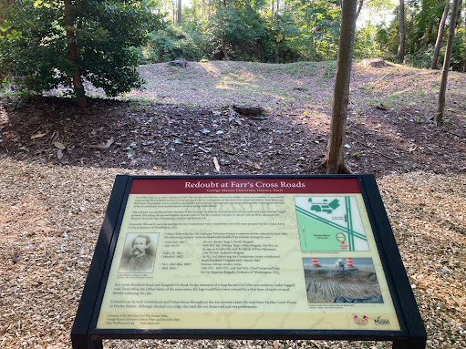
Groundskeepers have since cleared routes for access trails and installed two interpretive markers created by the George Mason-BRCWRT team.
 |
| 8th Green Machine Regiment Band performs at event (Joshua Cruse, GMU) |
The redoubt
was constructed by Col. Robert Rodes’ 5th Alabama Infantry, Ewell's brigade, in June 1861.
It was built on high ground along two well-traveled thoroughfares – the current
Braddock Road and Route 123 (Ox Road).
It’s difficult to know how many men were deployed at the redoubt at any
given time. It was used as an observation post and a command post for the
units/soldiers manning picket posts along the trench lines to the east or west
(depending on which side was controlling this part of Virginia) of the redoubt.
The redoubt at Farr’s Cross Roads was among several fortifications built to monitor and discourage Federal troops from marching from Washington and Alexandria, Va., toward Manassas Junction.
Dust kicked up by Federal troops in July 1861 signaled a Federal advance. When Confederate forces withdrew to their main defensive line along the Bull Run on July 17, the site was occupied by Union forces under the command of Brig. Gen. Irvin McDowell, according to the round table. The Battle of Manassas (Bull Run), the first major land battle of the conflict, occurred just days later.
The hastily
constructed fort exchanged hands during the war, but was held mostly by Union
troops, including the 16th New York, 1st New Jersey and 2nd
Massachusetts infantry. While it once had a parapet up to 6 feet high, most of
the ring currently is half that height.
Significant
commercial and residential development in suburban Washington has erased most
of the earthen structures erected by both sides, so it is somewhat of a minor
miracle that the redoubt survives, given it being bounded on all sides by
asphalt and buildings.
A BRCWRT article a few years ago detailed the project and partnership with George Mason.
“While
construction of the Mason Inn and parking lot and the enlargement of student
parking lot K has reduced the overall size of the site and potentially
obliterated some of the earthworks, the redoubt still remains and is in
remarkably good condition.”
Myers told
the Civil War Picket in an email that a 50-foot section of a trench line
presumably built by Union troops survives west of campus along Braddock Road.
 |
| Remains of the redoubt lie behind this marker on the George Mason campus (BRCWRT) |
“My first
thought, at the time, was how lucky we were that this site was here on the
campus, and not on private land, or in a real estate developer’s viewfinder,”
Platt said.
“After all,
if a preservation project were to happen anywhere in a highly developed
suburban landscape – if a site were to avoid getting ‘Fairfaxed’ – surely it
would happen at a university -- a place with a scholarly interest in studying
and preserving our historic and cultural heritage.”
Fairfax
County was home to numerous Civil War fortifications and features, a legacy
reinforced by the discovery of a cedar-logged highway near George Mason in
2014. The so-called “corduroy road” is believed to date back to the Civil War.
The
round table commissioned a drawing by GMU alumnus Nathan Loda of the area as it may have appeared in 1861.
 |
| The dedication took place in Parking Lot K (Joshua Cruse, GMU) |
Myers told
the audience on Oct. 7 that it was a day to savor what has been collectively
accomplished, but more work likes ahead.
“We continue to work with GMU to pursue additional
preservation and interpretation on the site - remnants of a stone building on the
site, site overlooking corduroy road discoveries in 2014 & 2015, remnants
of the farm road/trench line on the site, enhanced interpretation using virtual
and augmented reality technologies,” he wrote the Picket.
 |
| Wood chip-trail leading to Civil War redoubt (GMU) |

No comments:
Post a Comment